Top Posters


Popular Content
Showing content with the highest reputation since 06/24/2015 in Posts
-
It's kind of an interesting line of questioning to ask if something is necessary. You don't "need" a backpack. You can easily fold a tarp up into a pouch to hold all your gear and hang it from a sling. But not many people would make an argument not to use a backpack, despite the significant expense. Continuing the thought process, you don't need a tent, a tarp is just fine. You don't need a cook kit or water filtration, as you can cook on a fire or boil water to drink. Bottom line, most things in this hobby are optional. We choose to use things that make the experience more enjoyable and safer. As do trek poles.5 points
-
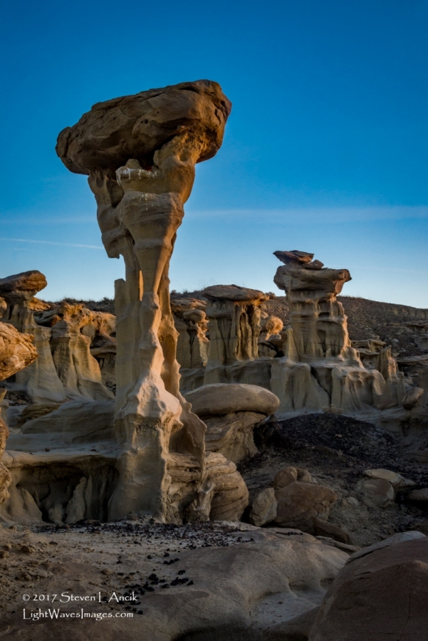
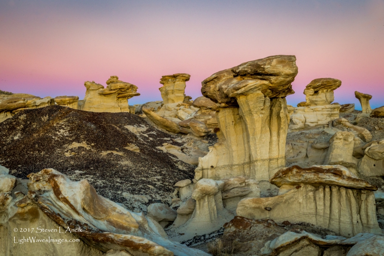
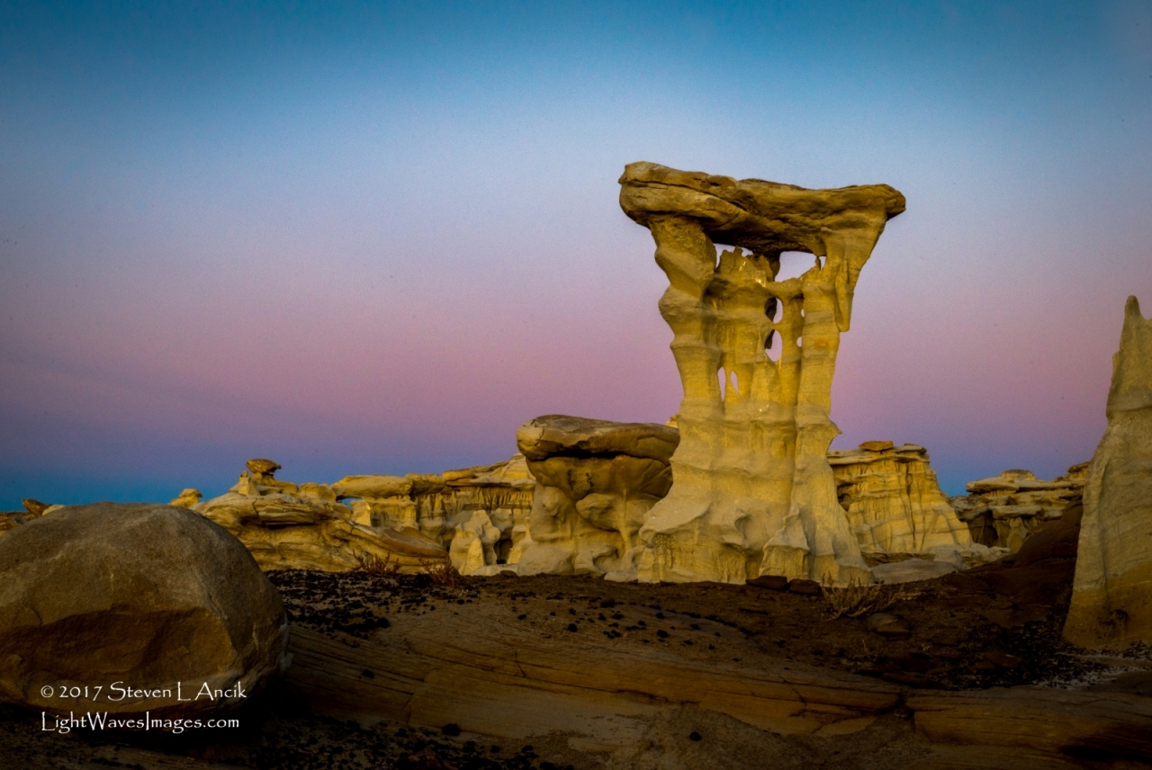
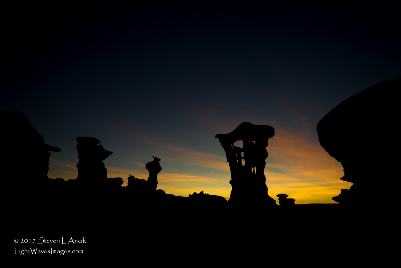
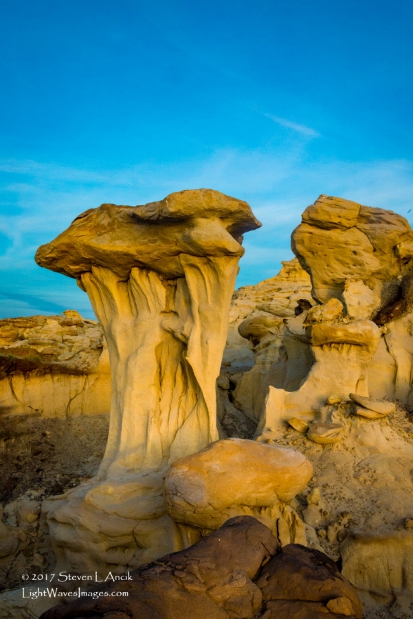
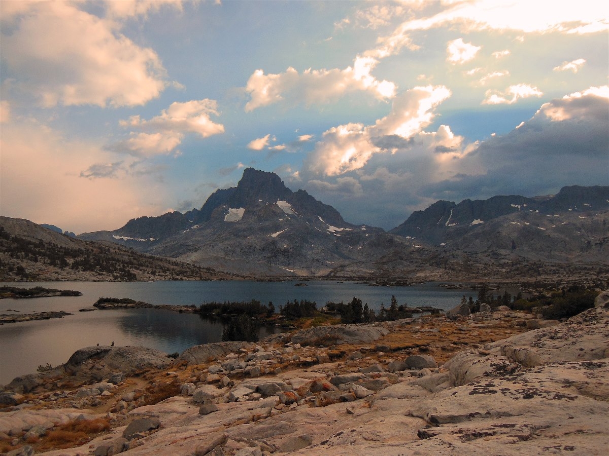
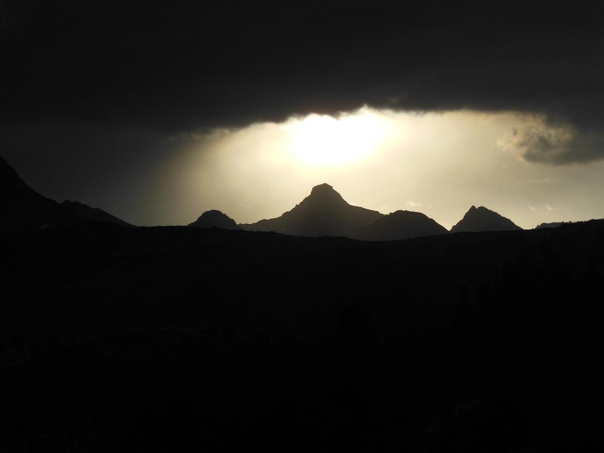
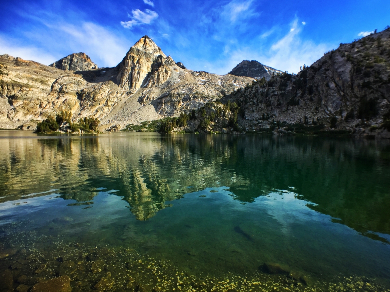
A bit of a followup to http://www.trailgroove.com/issue31.html?autoflip=17 I made a return trip to the Ah-shi-sle-pah Wilderness in October 2017. I had been to this rough badland area before where we saw the ‘King of Wings’ formation, but his time we were headed farther west toward the ‘Valley of Dreams’ area where the ‘Alien Throne’ was located. After miles of driving mostly unmarked dirt roads across the boring plains, we came to a spot in the road where there was one other car, and my GPS showed us to be a little over a mile from the destination. We loaded our backpacks and headed off toward the badlands. There were a scattering of interesting hoodoos on the way, but the best was yet to come. It had been a week of clear, sunny days without a cloud in sight. This day, however, was different - there were some high wispy cirrus clouds moving in, promising a colorful sunset, and we were not disappointed (especially me!). We arrived at the eastern part of the ‘Valley of Dreams’ in late afternoon and it struck me as being some of the densest concentration of hoodoos and bizarrely-shaped rocks that I’ve ever seen! It was both a photographer’s dream and a photographer’s nightmare - so many shooting possibilities. We wandered around the hoodoos slowly making our way to the west. Once on the west side, we met a couple from Germany (and the people whose car we had seen earlier). They had been out both the evening before and that same morning. They were in the midst of a 25-day trip through the American west. They pointed out the ‘Alien Throne’ and we all proceeded to take piles of pictures of that hoodoo and the surrounding area. The sunset was spectacular as hoped for, and even after sunset the pictures show the otherworldly beauty of this spot. We set up camp nearby and had our coldest night of the trip (probably around 40 degrees). I got up early the next morning, which was once again mostly clear skies, but still shot a few excellent pics. Pictures #2, 4, and 5 are the Alien Throne. First picture is a Giant Mushroom - over 6 feet tall.

 4 points
 -
I know this is an old post, but I noticed that there were no factual data posted about the safety of aluminum cookware. As a critical thinker and an REI employee, I believe that people should make informed decisions based on facts from credible sources, not someone's own personal beliefs. (Disclaimer: This post in no way represents the opinions or recommendations of REI and I am not posting as an employee, but as a private individual.) According to the Centers for Disease Control (CDC), aluminum is safe to cook with. Aluminum is naturally present soil, water, and the air, but account for minimal exposure in humans. Primary exposure (about 7-9 mg/day) is via ingestion of aluminum containing food, including baked goods and goods containing anti-caking and coloring agents. Aspirin contains 10-20 mg. of aluminum and antacids have 300-600 mg of aluminum hydroxide, very little of which is absorbed. Most of the aluminum ingested passes through the digestive system and leaves the body in the feces. Smaller amounts that enter the bloodstream are voided via urine. Aluminum is applied topically via cosmetics and antiperspirants. Aluminum poses no health risks in these very minute exposure because healthy individuals do not store aluminum. However, some people who have kidney disease do store aluminum that enters the bloodstream as the kidneys fail to remove it. Some studies show aluminum in high levels are correlated with Alzheimer's; but other studies contradict that finding and there is no scientific consensus of a link between aluminum and Alzheimer's. The CDC recommends that concerns regarding typical aluminum exposure should be addressed by reducing or eliminating aluminum containing processed foods and avoiding cooking acidic foods in aluminum pots, although the levels of aluminum found in food cooked aluminum pots are safe. From here: https://www.atsdr.cdc.gov/phs/phs.asp?id=1076&tid=34 With regard to anodized aluminum, according to Clemson University, anodized aluminum is hardened to prevent reaction to acidic foods cooked within, but storing acidic foods in the pot does cause pitting like non-anodized aluminum contact with acidic foods. From here: https://www.clemson.edu/extension/hgic/food/pdf/hgic3864.pdf Since it's uncommon for backpackers to cook or store acidic foods in their cookware, I would suggest that unless you have kidney disease you should be fine with aluminum pots, whether anodized or not, and would be better off basing your decision on factors other than safety such as weight, cost, and durability. Here comes my "gear nerd" answer: Titanium is chosen primarily for weight-saving and strength, but is generally much more expensive than aluminum/anodized aluminum. Aluminum is an excellent heat conductor making it a more efficient metal for cooking. However, the difference in heat transfer is negligible because even though titanium is more of an insulator than a conductor of heat, its greater strength allows for extremely thin walls which pose little barrier for heat to pass through. This is why I can't hold my titanium pot filled with boiling water with bare hands and why it's as efficient as an aluminum pot. Whether it's worth the added cost is really an individual choice. I am personally very happy with my 600 ml titanium cup that weighs 88 grams and can easily boil 2 cups of water. But I would also greatly consider anodized aluminum as an alternative since the weight cost is negligible and the cost is much less. The GSI Hallulite Minimalist is a 600 ml anodized aluminum pot with a cover, folding plastic spork (useless, IMO), a silicone pot gripper, and an insulating sleeve for 177 grams. If you ditch everything but the pot, you're down to 92 grams, only 4 grams heavier than titanium for (currently) $9 less. Hope that helps anyone considering new cookware or replacing old cookware.4 points
-
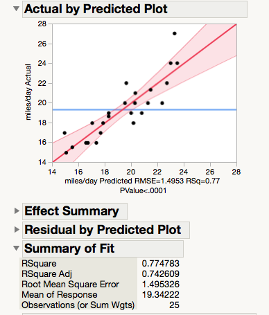
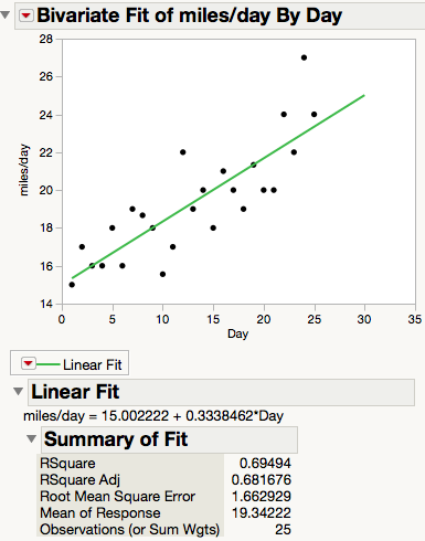
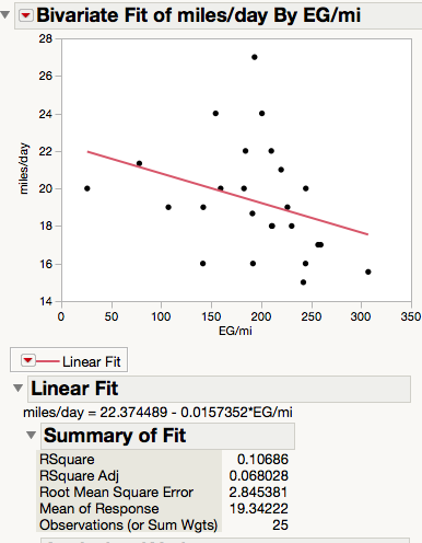
So there's a foot of snow on the ground, the temps have been in the single digits (both positive and negative). I should get out and go for a ski, but the NWS says winds of 30+ MPH in the high country. Clearly, the proper thing to do today is start planning a long-distance hike. For section-hiking the PCT, I have relied on Craigs PCT Planner to help me estimate how many miles I'll hike per day and thus how many days it will take to get from one resupply point to another. It does this by having you put in an average pace, hours hiked per day, and an elevation gain factor. It works pretty well, and I highly recommend you use it (and donate) if you are hiking the PCT. But I am thinking of the AZT this spring and there is no ready-made app that I know of for it. But I do a lot of quantitative analysis in my line of work, and wondered if I could come up with my own predictive formula. I hiked the PCT from Walker Pass to Lake Tahoe last summer. Thanks to Halfmile's PCT maps and app I could estimate the miles hiked and the elevation gained and lost pretty accurately. I put these into a data table in JMP, and then added in other factors that I thought might affect my daily mileage: days on the trail, days of food carried, ± bear canister. I put these together into a model that also looked for interactions between factors and non-linearities within them, and then ran multivariate regressions to determine which were the most influential and fit the data best. The model did a pretty good job: About 77% of the day-to-day variance in miles hiked is accounted for, and the average error between predicted and actual miles hiked is 1.5 miles. What surprised me was the factor that turned out to be far and away the most influential: how many days I had been hiking. In fact, if I just plot miles per day vs days on the trail I get a pretty good correlation: This wasn't totally unexpected. I knew I was hiking longer distances as I got in better shape. But I was surprised at just how little influence other factors like weight carried or elevation gain or loss had on mileage. Here's the plot for elevation gain vs miles hiked: It has a negative correlation, just as you'd expect, but the effect is fairly small and in fact is of weak significance (P = 0.11 vs P < 0.0001 for trail days). A Pareto plot illustrates the relative influence of the factors (all other factors were insignificant and were left out of the model): That central term accounts for the non-linearity of the EG effects, meaning that going from 400 ft/mile to 500 ft/mile slowed me down more than going from 100 ft/mile to 200 ft/mile. I don't think I have to convince anyone in this forum that this makes sense. There is an obvious problem with this model - it predicts that if I were on the trail for 50 days I would be hiking some 35 miles/day, which is not likely. My mileage would surely flatten out at some point in the hike, if for no other reason than that I like to swim, fish and take naps when the conditions are opportune. The prediction expression ends up being miles/day = 18.4 + 0.31*Day - 0.014*EG/mi + (EG/mi-193*((EG/mi-193)*-0.00014). It's fairly easy to plug this into a spreadsheet and limit the intercept + Day factors to ≤ 25 miles a day and then use the rest of the equation to adjust for elevation gain. Of course this just applies to me. Your mileage, as they say, may vary. But I wonder if anyone else has seen a similar pattern on their long hikes.
 4 points
 -
Hike to Backcountry Hot Springs Selway-Bitterroot Wilderness Clearwater National Forest Idaho November 26-28, 2015 Soaking in a hot spring and stargazing on a winter night certainly meets the definition of sublime. When the hot spring is reached after a delightful five-mile hike and you have it all to yourself, the charm of the experience increases exponentially. When there’s just enough snow on the ground to provide a lovely contrast to the lush evergreen forest without causing the slightest inconvenience to camping or hiking, then the setting and experience approaches perfection. It should go without saying that finding myself in such a blissful place on Thanksgiving that I was indeed grateful, peaceful, and content in the utmost. Being an only child of divorced parents and having lived a few hours away for a decade, and a day’s drive from extended family since birth, I’ve allowed myself a certain amount of flexibility and indulgence -- perhaps even selfishness -- around the holidays, for better or worse. For most of my adult life I’ve spent the Thanksgiving holiday with either girlfriends and their families or out backpacking. In each circumstance I’ve created some cherished memories. Thanksgiving with my friend John in the Joyce Kilmer-Slickrock Wilderness of southern Appalachia, tents pitched amidst old-growth poplar trees and a glorious Black Friday climb to the Hangover and its magnificent vista. Thanksgiving spent gorging on gourmet food and bourbon with a girlfriend and her family in the heart of Kentucky’s Bluegrass region -- followed the next day by the two of us heading out on one of the most rugged overnight trips I ever did in the Red River Gorge, working off the turkey and camping at an obscure waterfall. So, I suppose on this most recent Thanksgiving sojourn I was merely continuing a tradition I started in my early 20s rather than breaking from any tradition. Given its popularity and prominence in numerous guidebooks and on the Internet, I’d delayed a visit to this destination until I felt that circumstances were in my favor to have at least 24 hours of solitude at such a prime location. Between the Thanksgiving holiday, the frigid forecast (highs just below freezing, lows on either side of 10 degrees), and the short days of late November in the northern Rockies, I put my chips on those odds and planned the trip. It was five degrees when I loaded my car up and left Hamilton and the sun was shining on the snowcapped peaks of the Bitterroot Mountains as I began the two-hour drive to the trailhead. The drive was breathtaking and, given a recent snowstorm, the road conditions were surprisingly decent. Two feet of snow were present at the mountain pass as I crossed into Idaho and began the descent to the Lochsa River, which I would follow to the trailhead. As I lost elevation, the snow thinned out considerably and was patchy in the campground where I parked. Shortly after 11 a.m., I shouldered my pack in the empty trailhead and headed up the trail. It felt like the temperatures were in the upper teens and there wasn’t a cloud in the sky. The trail started off with a steep climb that got my blood flowing and my zippers opening. It remained a gentle grade for the next few miles and I vented or zipped up according to my level of exertion, the amount of shade I was in, or the combination of the two. The views of the Boulder Creek drainage were scenic, but a but intimidating as I knew an unbridged creek crossing loomed ahead of me. I took a break at the wilderness boundary at two-miles then continued on to the crossing. Boulder Creek, true to its namesake, featured a streambed of uncountable boulders and rushing water. Ice crept in from each bank and surrounded the rocks, while a swift current pushed frigid water downstream via the path of least resistance. Crossing this creek would be the crux of the hike and I was determined to take my time and minimize the not-inconsequential risk of crossing a large stream in sub-freezing temperatures. First, I took a sip of water. Then I put traction devices on my shoes and ensured my trekking poles were adequately locked and extended. Finally, I shifted my pack and zipped up my jacket so that I was as comfortable as possible. Satisfied that I’d adjusted all the variable I had control over in my favor, I looked for the best place to cross. Despite the abundance of boulders, all were inconveniently spaced and covered with snow and ice. I spotted a downed tree a few hundred feet downstream that resembled a bridge and made my to it. Not wishing to tempt fate, I straddled the snow-covered log and scooted across. Although I was on solid ground after dismounting the log, there was still another channel of the creek to cross. Fortunately, this was a much smaller channel of the creek and I was able to walk across a downed log to the other side of the creek without incident. While the crossing had been as good as I could have hoped for, I had inadvertently ended up pretty far downstream from the trail. Fortunately, the forest wasn’t very thick, although it was boggy in spots, and I was able to easily work myself back towards the path. When I encountered a large downed tree, I joked to myself that “Well, trees usually fall across trails, so I might as well see where this one landed.” I couldn’t help but smile when I stepped off the tree and onto the trail. The last half-mile to the hot springs was bathed in the glorious and fleeting light of early afternoon in winter and was especially fragrant with spruce and pine. As the narrow footpath closed in on the hot springs, my anticipation increased. When I saw steam wafting through the forest I became almost ecstatic and knew I had arrived. I scoped out the springs and dipped my fingers in the warm water of the pool closest to the trail before embarking on the search for an ideal campsite. The campsite I found was excellent -- a few hundred feet from the hot springs, above the main trail, no widowmakers nearby, it was hard to ask for more. There was a heavy dusting of snow in the forest but the dense canopy cover allowed me to set my tent up on bare ground. After getting my campsite situated and hanging the bear line, I headed over to the hot springs. I won’t bother trying to describe in detail what it was like to ease into a steamy pool of water on a sunny winter afternoon in a lush mountain forest. Incredible is probably the most accurate word I could use. Perfect would also be suitable. The water temperature, the size of the pool, the frost clinging to everything within a few yards of the springs, the sound of the water as it flowed from pool to pool -- there was no opportunity for improvement. I floated around for just over an hour with half of a 3/4 length foam sleeping pad allowing me to perch on various rocks and logs in utmost comfort, and supporting my lower back as I floated in the middle of the pool. A few sips of bourbon and reading “To Build a Fire” by Jacking London for the dozenth time or so made the time fly by. Just as the day began to darken I exited the pool and cooked my Thanksgiving dinner of pasta, spinach, mushrooms, tuna and grated cheese. Not quite a turkey dinner, but not half bad by any means. Once dinner was cleaned up, I took a thermos of hot chocolate back to the hot springs for a starlit soak. Words fail at communicating the bliss of the experience, so I’ll quit while I’m ahead. I soaked for maybe two hours before getting out, putting on a fresh wool baselayer, and heading to the tent. I was supremely relaxed but not exactly tired, so I read a bit more before turning off the tiny lantern that lit my small tent. Perhaps it was the bourbon, or maybe it was my sheer giddiness at the way the trip was playing out, and I suppose it could’ve just been the cold weather, but I felt a special kinship with my sleeping bag as I zipped it up and tightened the draft collar. I mentally composed an ode to my down-filled friend to the tune of Neil Young’s “Long May You Run”, re-purposed as “Long May You Loft”, hopefully the backpackers out there will appreciate the sentiment and the Neil Young fans will forgive me: We’ve been through some nights together Chilly mornings and snow covered tents You’ve kept me warm in frigid weather Long may you loft I added a fleece pullover during the night, and a midweight set of wool bottoms in the early morning hours, but this was to be expected. My 15 degree bag was pushed a bit past its limit, which is why I’d brought my puffiest down jacket and thicker wool layers. When I exited the tent in the morning to retrieve the food bag it was about 8 degrees, according to the keyring thermometer I’d set on a branch near the tent. Not being in an hurry, I took the food bag back to the tent and climbed back into my sleeping bag, then sprawled out and made coffee and oatmeal just outside the tent. I had a liter bottle of water in my sleeping bag to keep it from freezing and another liter in a Platypus in a minor pool of the hot springs to keep it from freezing. I sipped coffee in the comfort of my sleeping bag, read some more Jack London, and made another round of coffee before finally leaving the tent and heading over the hot springs for a late morning soak. Starting the day with a cup of coffee and a soak in a hot spring in an idyllic setting while reading classic stories of adventure and peril in the Yukon is something I would highly recommend. Determined not to have a sedentary day, I decided to hike up the trail as far as I could to scout it out for a future trip. On the map, it seemed like a great loop hike could be put together. I ventured up the trail only a few hundred yards before it faded into fallen trees. I tried to push through in hopes the path would re-appear, but to no avail. It seemed to just fade out. I’m not trying to give myself too much credit, but I’ve followed some notoriously faint and/or rough trails in my time as a backpacker. Deep Creek Trail and North Fork Citico Creek Trail in the Joyce Kilmer-Slickrock Wilderness/Citico Creek Wilderness, a seldom-used mid-elevation path in the Chiricahua Mountains, and a decommissioned Forest Service trail to an unnamed lake in the Bitterroot Mountains immediately come to mind. But on this trail I wasn’t able to make much progress. Maybe it was the downfall and dense vegetation, maybe it was the snow, or maybe it was the fact that there was a hot spring waiting for me, but I turned back after only a half-hour or so of forward progress. I did wander down to the creek during this outing to admire the beauty of the partially frozen stream for a moments, which was time well spent. Once back in camp I had -- you guessed it -- another soak before enjoying a delicious snake of cheese, pita chips, fruit strips, and jerky, along with a warming cup of mint tea. Shortly after I finished my feeding frenzy, two other backpackers arrived. These dudes reminded me of myself and my friends, which is meant as a compliment. They were great company and oddly enough had lived in east Tennessee earlier in their lives, which is where I was born. So we had some common ground (pun intended) in that we had each spent a good bit of time in Great Smoky Mountains National Park. While I valued my solitude, my assumption that any folks who would spend a frigid Thanksgiving weekend at a backcountry would probably be pretty good people was proved correct. I enjoyed another soak before dinner while getting to know my neighbors. Thai peanut noodles with chili-lime jerky and fresh-squeezed lime juice as on the menu, and I enjoyed an aperitif of Kentucky bourbon while my stove did its work. With a full stomach, I headed back to the hot spring to enjoy another night of stargazing. Seeing shooting stars from a hot spring is a great way to end a day, and the conversation with my springmates was interesting but not overwhelming. We all seemed to know how to appreciate silence, which unfortunately doesn’t seem to be a universal value these days. Zipped into my sleeping bag, I got another great night’s sleep and awoke to a morning just as chilly as the one that had preceded it. A cup of coffee made packing up bearable, as did the promise of one last soak before hitting the trail. I tried with my utmost to internalize the beauty around me as I slipped in for the last time. Steam rose and mixed with frigid air, depositing beautiful frost formations on rocks and logs; and on the living carpet of moss that grew from log to rock to ground and back. An impossibly beautiufl scene and one that was nearly impossible to leave. Nevertheless, after a final soak I headed down the trail with a feeling of rejuvenation and gratitude. As accommodating as the hot spring had been, the crossing of Boulder Creek was the exact opposite. I took a different route than the one that I had used to cross a on my trip over and it was a slight improvement in both safety and convenience. Aside from the fact that I was moving further from the hot spring and my time in the woods was winding down, it was a great hike out. The slight downhill grade made for efficient hiking and the light pack (owing to food and fuel consumption) was noticed and appreciated. I made it back to the trailhead in the middle of a sunny afternoon. I changed into fresh clothes and made a cup of coffee for the road before hopping in my vehicle and beginning the gorgeous drive home. Despite radiating satisfaction on the return journey, I was just a bit disappointed to know that baths at home just wouldn’t feel the same after this trip.4 points
-
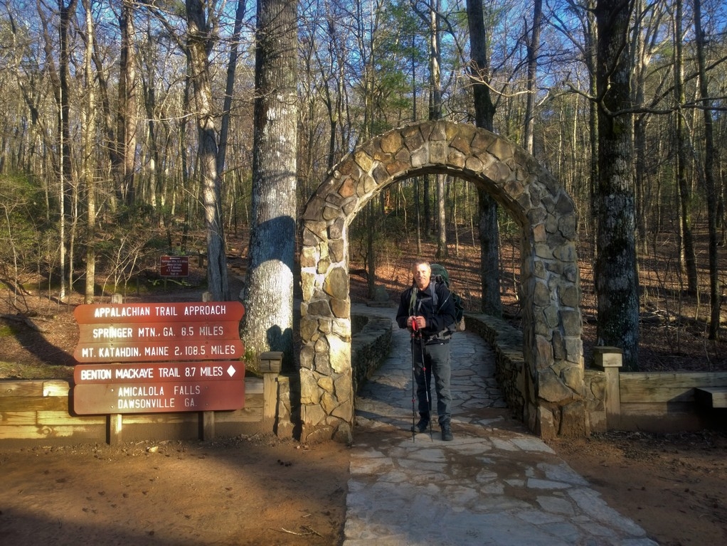
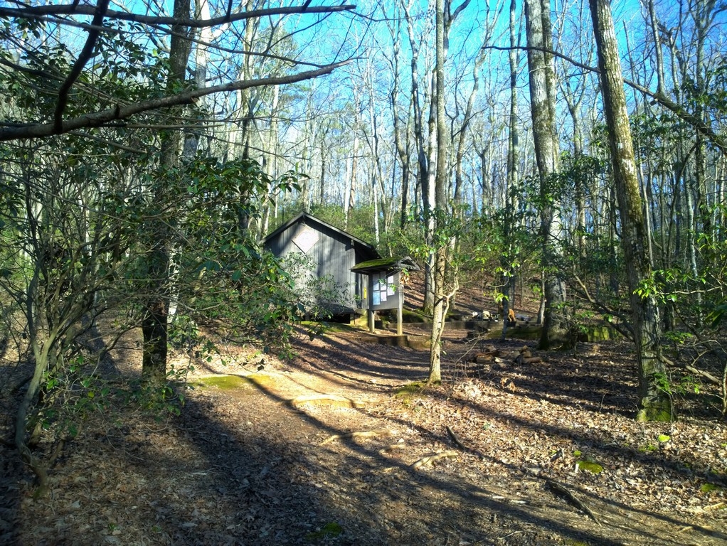
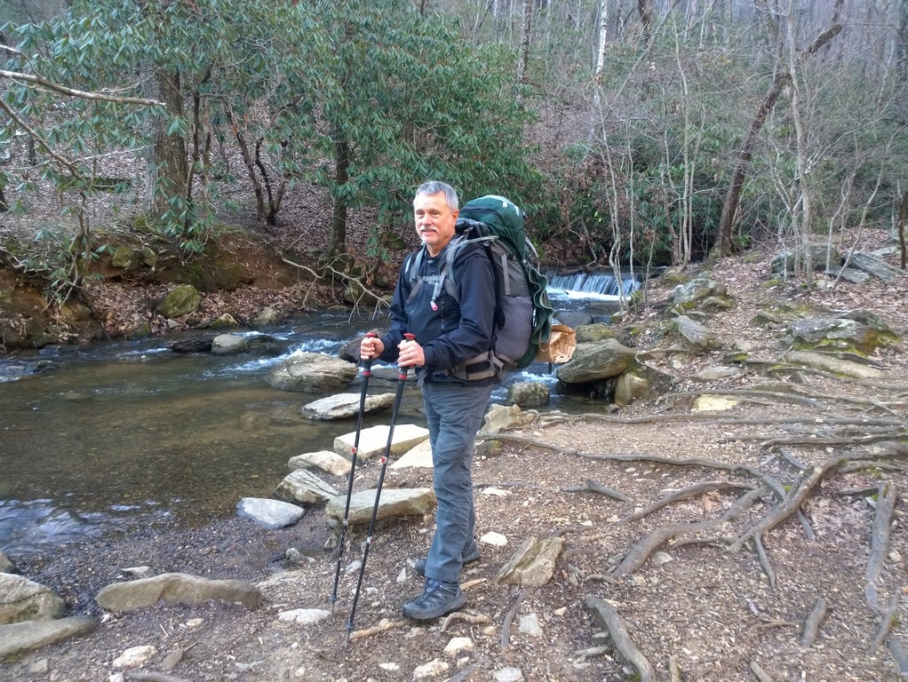
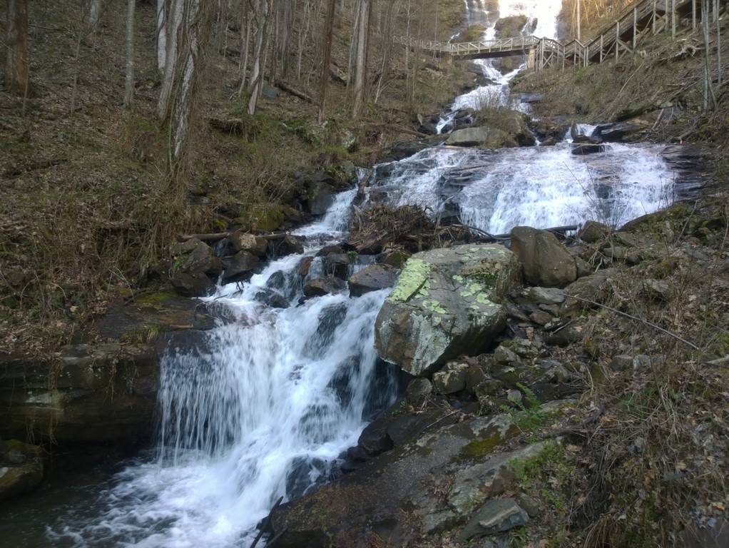
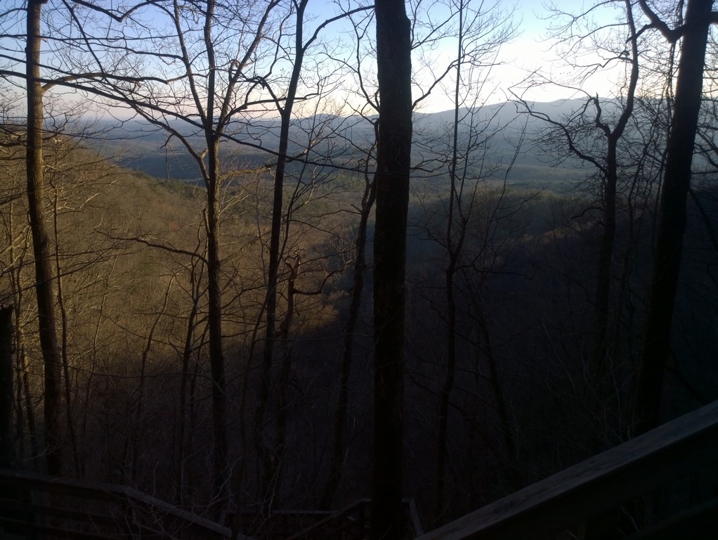
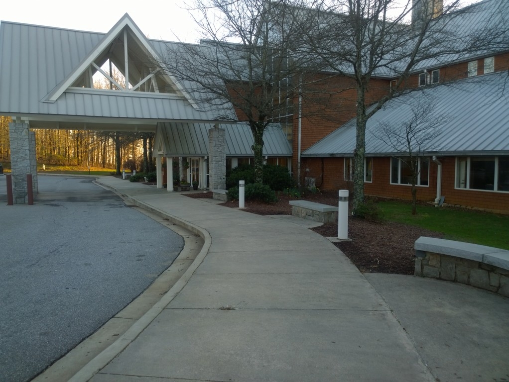
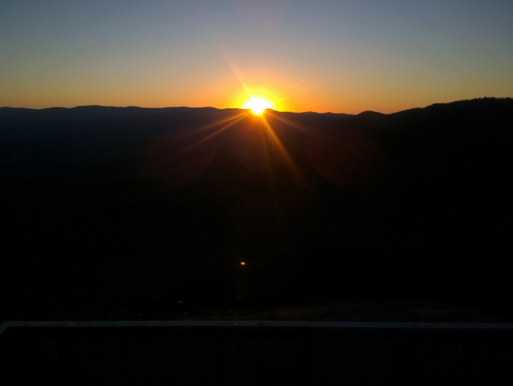
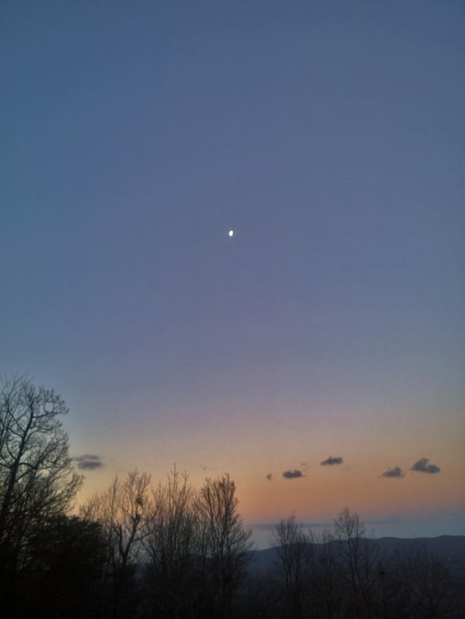
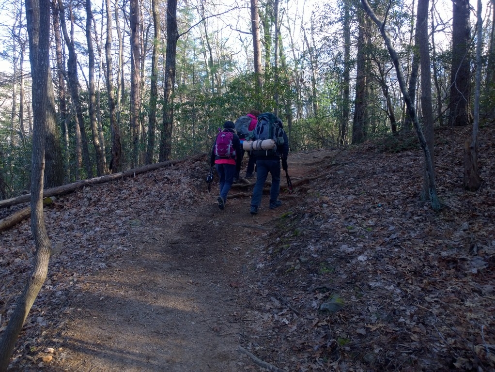
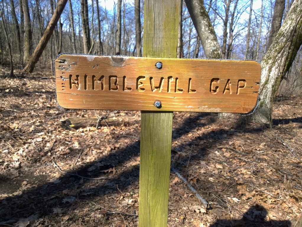
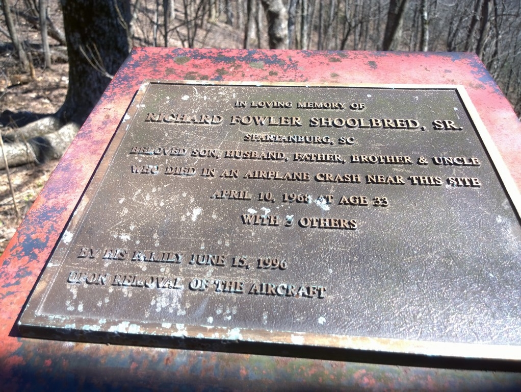
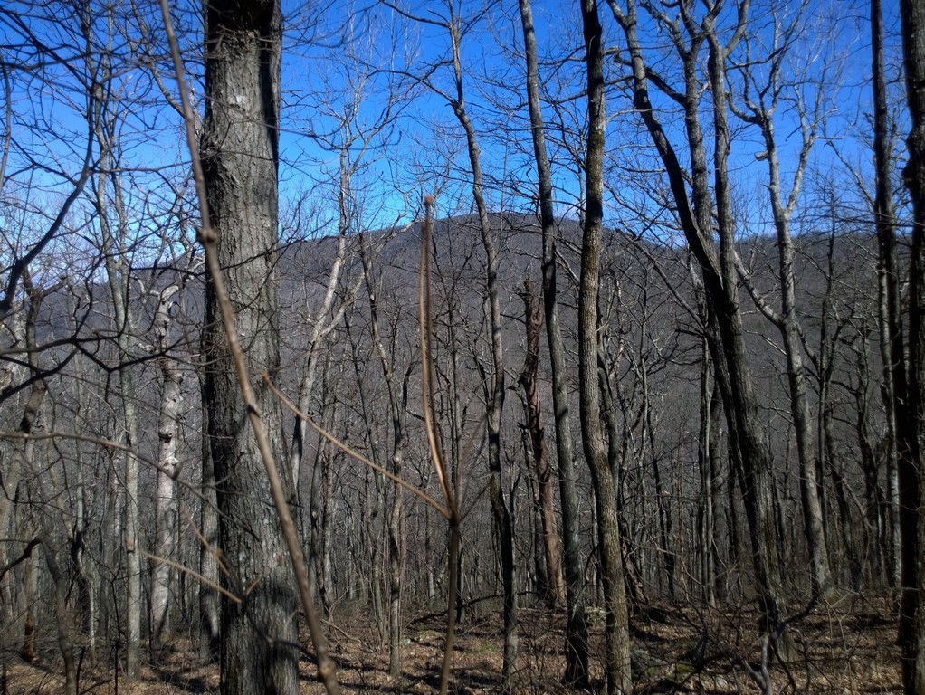
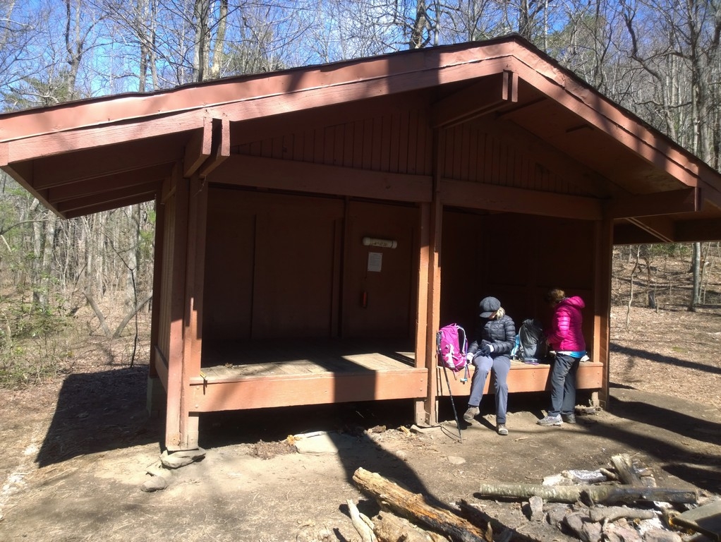
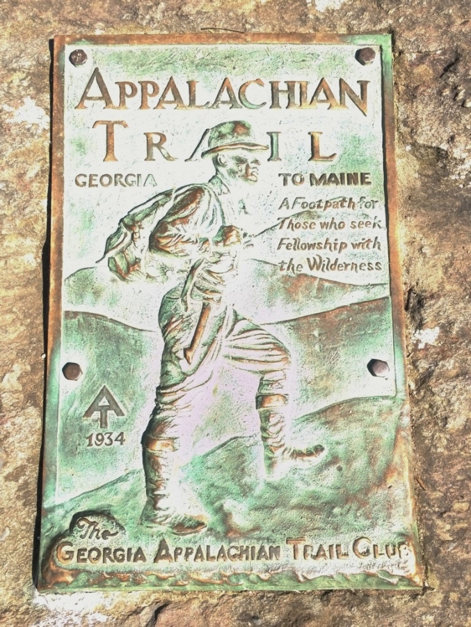
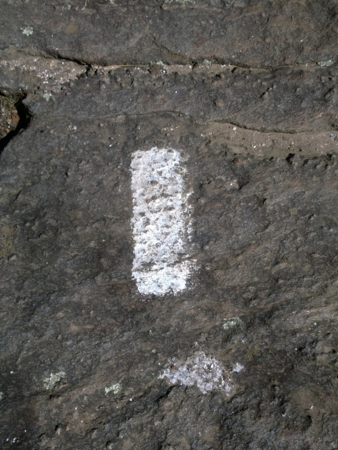
After something like three years of talking about it and months spent making plans, my good friend and hiking companion, Wayne Garland, has finally set out on his attempted thru-hike of the Appalachian Trail. In October, at the age of 70, Wayne retired from a long and distinguished career as a Paramedic, providing emergency medical services here in Oconee County, South Carolina. One of Wayne's stated goals for his retirement, was to do a lot of traveling. I think that it's safe to say that he's accomplished that goal already. In the months since his retirement, he's already traveled to the Netherlands, Germany, Luxembourg, and Guam. In January, he also traveled to Vietnam and Cambodia. As a veteran of the Vietnam War, that trip had represented the first time that he had been back to either country since the end of the war more than 40 years ago. Wherever his travels have taken him, Wayne has made it a point to hike some of the local trails. While in Europe, one of the notable hikes that he did was to the top of the Feldberg in Germany's Black Forest region. At 4,898 feet, the Feldberg is the highest mountain in both the Black Forest and in all of Germany outside of the Alps. According to Wayne, though, the hardest hiking that he’s ever done anywhere was along the grassy trails of Guam's southern mountains, to the summit of Mt Schroeder. In addition to the terrain, which was very steep and rugged, the hiking was made more difficult by an abundance of razor-sharp Sword grass. The Sword grass is so sharp that wearing long pants, long sleeves, and gloves is a must. In places, it was more than eight feet tall and so dense that he couldn't see the trail or even the other people that he was hiking with. Another of Wayne's goals for retirement is to thru-hike the entirety of the Appalachian Trail, from it’s southern terminus in Georgia, to it's northern end atop of Mount Katahdin in Maine, nearly 2,200 miles away. To Prepare, Wayne has been hiking or backpacking with every available moment. In 2016, although he was still working 72 hours per week, he hiked more than 1,400 miles for the year and averaged nearly 120 miles per month. Unfortunately, an Achilles injury and tendinitis sidelined Wayne for the first half of last year. Now that he's fully recovered and with the end of winter approaching, Wayne is ready to set out on his next adventure. Two of Wayne's close friends and fellow hikers are Pam Hembree, and Jan Haney. On Tuesday, March 6th, Pam, Jan, and I, drove with Wayne from our homes in Upstate South Carolina, towards Dawsonville, Georgia and Amicalola Falls State Park. Our intentions were to accompany him as he hiked the Approach Trail that runs between the State Park and the official start of the A.T. at the summit of Springer Mountain. First however, we had to drive along Forest Service Road 42 to a gravel parking area about a mile north of the summit and leave our vehicle, then wait for the shuttle that would take us the rest of the way to Amicalola. Our shuttle driver's name was Ron. Ron is a super nice guy and is very knowledgeable, having previously served as a Park Ranger for more than eight years. Through no fault of his own, Ron was running a couple of hours behind schedule. By the time that he had picked us up, it was already about a quarter after four. We needed to be at the Park Office before 5 pm so that Wayne could register and receive his 2018 A.T. Leave No Trace hang tag. It was close, but Ron got us there with a couple of minutes to spare. Wayne was the last one to register on this particular day and is number 719 to register overall. Next, we stopped at the famous stone archway behind the park office and had Wayne pose while we all took pictures. The oft-photographed landmark marks the beginning of the approximately 8.8 mile long Approach Trail. For today, though, we would only hike the one mile from the arch up to the Lodge at Amicalola, where we had planned to spend the night. Along the way, we climbed 604 steps, gained about 800 feet in elevation, and got up close and personal with the park’s namesake waterfall. Amicalola Falls plunge a total of 729 feet from the top down to it's base and are the tallest in the southeast. At the lodge, we watched a beautiful sunset from the balcony, ate dinner at the Maple Restaurant, then went to our rooms. There, we took care of some last minute details before trying to get in a few hours of sleep. The moon was still high in the sky early Wednesday morning when we woke. After showering, then eating a quick breakfast, we set out on the Approach Trail. The morning air was cold, with the temperature ranging somewhere between 26 and 30 degrees. The wind blew hard on us the whole day, gusting to close to twenty miles per hour. Although it was a blustery day, within minutes of beginning to hike, we had warmed up considerably. Except for our hands and faces, it wasn't bad at all. While not terribly difficult, the Approach Trail is certainly no pushover either. I've been told that if you can do the Approach Trail, then you can do the whole trail. I'm not so sure about that. I think that may be at least a bit of an overstatement. It will, however, definitely make you think twice about lugging a heavy backpack up and down mountain after mountain, mile after mile, day after day, for five or six months. Heck, it gave me second thoughts, and I’m not even the one doing the thru-hike. Early in our hike, the trail had climbed steeply, then leveled as it passed through an area where there were lots of Hollies growing. Some of the Hollies were just beginning to bloom. Later, we passed through Nimblewill Gap and by a memorial there to the people that had died in a small plane crash near that site in 1968. With about a mile-and-a-half to go, we reached Black Gap Shelter, where we stopped to eat our lunches. At the shelter, we met a fellow who's trail name is Silver Bullet. At least that had been his name. That is, until a former army medic told him that “Silver Bullet” was military slang for a shiny rectal thermometer. Now his trail name is Silver, just Silver! From the shelter, the trail climbs another 600 feet by the time that it finally reaches the top of Springer. At the summit, there is a register and two plaques. One plaque was provided by the US Forest Service and is fastened to a boulder. The other plaque was placed there by the Georgia Appalachian Trail Club in 1934 and is attached directly to the rock-face. Also at the summit is the first official white blaze. It's been estimated that there are 165,000 white blazes along the Appalachian Trail. If that's true, then Wayne only has another 164,999 more to go. After spending a few minutes taking pictures, we hiked a mile from Springer, down to where we had left our vehicle the day before. There we said our goodbyes to Wayne, prayed for his safekeeping, and watched as he headed up the trail alone. We wondered what he must be thinking and how he was feeling. Wayne is mentally tough and has a lot of good old fashioned grit, so unless something unforeseen or beyond his control happens, I'm confident that he'll do well. Happy trails, my friend! Update: at the time of writing (03/21/18), Wayne has been on the trail for fifteen days and has hiked 173 miles, including the Approach Trail. He's at Fontana Dam and about to enter the Smokies. He's been given the trail name Defib, a reference to his background as a paramedic. He's had to contend with a broken tent pole, a lost down vest, strong winds, snow, and temperatures that have dipped down into the teens. Even so, he's still plugging away.
 3 points
 -
Four days of water is around 28 pounds if you bring a gallon a day. I have done one backpacking trip in Big Bend near the Mules Ears. We went around New Years in early Jan. I went with 3 geologists, so we hiked from spring to spring using topo maps. We were never on a trail. The weather was great, near 70 during the day and freezing at night. Our rule was if we could not find the next spring at the end of a day we would back track to the last known water.3 points
-
Danner3 points
-
Looks like the Leave no Trace Center just published a post in regards to them taking public input on this issue and concern. If these issues are important to you in regards to social media, or any type of media for that matter, here's the link: https://lnt.org/blog/social-media-and-8th-principle-discussion3 points
-
I like to carry a GPS when I hike or backpack. I usually carry an extra set of batteries for every 2 days I plan to be out. About 8 years ago I started out on a 70 mile loop trail. An hour after I started I checked the GPS and it had quit. Dead batteries. In the next 2 hours I used all the batteries I had and all were dead. I had picked batteries out of the wrong drawer. I was depending on the GPS because I knew I would probably lose the trail about half way. If I was totally lost the GPS would show nearby roads and wet areas. Fortunately paper topo maps and compass don't need batteries. It took 8 days to do a hike that should have taken 5 or 6 days. Now I always take extra batteries that are still in the package. I have forgotten a few things. Once I forgot my hiking poles - which are also my tent poles. I cut 2 saplings and carved to the right length. Another time I forgot my spoon. My evening meal is always soup. Carving a spoon is much harder that tent poles.3 points
-
Author here. As I said directly in the article "Obscurity, not secrecy." Tell about the great place. But perhaps not give the exact breadcrumbs.3 points
-
Let me give you some perspective from a law enforcement officer: 1. If you are camping illegally and practicing LNT ethics, I might give you a warning and tell you to be elsewhere come the next day. 2. If you are camping illegally and practicing LNT ethics, but disregarded my posted sign that said NO CAMPING, it will cost you about $200. There's a reason that sign is there. And you'll have to break camp in the middle of the night. 3. If you are camping illegally and not practicing LNT ethics--booze, bonfires, litter, cutting down trees, etc, you are going to make a hefty contribution to my state's wildlife management fund. Wilderness, such as it is nowadays, needs to be protected.3 points
-
My suggestion would be to choose a destination that's compatible with what you're looking for. As an example, I often hike with a dog, and personally I like to choose my own campsites each night rather than stay in designated or reserved sites on a schedule. As a result of one or the other you don't find me in the National Parks very often and instead I tend to look for wilderness areas where dogs are allowed on the trails / in the backcountry and camping requirements fit my style a little better.3 points
-
First semester of college. A friend and I decided to summit Utah's Mt. Timpanogos (in the dead of winter). Rented snow shoes and an ice axe (with no knowledge how to use either), ended up spending a long cold night just a few miles up the trail on a steep side slope in chest deep powder. No shelter. Blizzard. Avalanches rumbling down all around us (covered our tracks) through the night. Ya, I'm lucky to be alive. Hundreds of backcountry miles later, I now have a profound respect for nature!3 points
-
I saved up enough vacation this year to go on a three week road trip. The plan is to do two-night, three-day trips. I'm still working out all of the specifics because I'm trying to meet up with friends in a few places, but right now this is the plan: Start in the Needle Mountains in Southern Colorado, then head to the Flagstaff or Sedona area. Afterwards I will meet up with some friends south of Salt Lake City and find something cool to check out. Next I head to the Jarbridge Wilderness in Nevada, then North to the Sawtooth Wilderness followed by some time in the Wind River Range (Aaron, route suggestions?). Then to wrap it all up, I'm meeting my Aunt in RMNP with plans to bag Long's Peak, we already have our site reserved at the boulderfield. August can't come soon enough!3 points
-
The Readers Digest version. This is probably my 5th backpack trip. Ever. A quick overnighter and another grand adventure in the books. 16+ mile round trip overnight backpack to see what I have dreamed of. Trail Notes: The Range of Light. Every step uphill is a step closer to Nirvana. Every dog on the trail was warmly greeted with a "Hi Baby!" How can my hips have outgrown my mummy bag?When the weather man says no rain, be sure to bring a rain jacket...always. Because it will rain. Because it will hail. Spur trails are an adventure in themselves. Bouldering! Sometimes, one is not really lost, sometimes one just doesn't know where the trail is. Someone who shall remain nameless thought it was a brilliant idea to pee in a gallon baggie in her tent instead of stumbling around the boulders in the cold, dark night. Someone who apparently is not a genius and who shall still remain nameless should be sure there isn't a hole in said baggie. Welcome to the reenactment of Moses parting the Red Sea...er...Yellow Sea! Tidal waves of pee. Pre-dawn silent laughter. Good times with great ladies. Daydreaming of the next adventure already.
 3 points
 -
Here is my trip report blog post on the Scott Paul Loop backpacking trip with my 9 month old Aussie, Brook. She experienced snow for the first time, the video in the post will give you a glimpse of a 9 month old Aussie having a wonderful time.3 points
-
Can't sleep in the backwoods? Easy solution: join the Army or Marines, you'll learn to sleep anywhere and everywhere. OK, that may sound a little dramatic, but the science behind it is worth exploring. If you're able to, start by taking naps in less than ideal places. The couch, the floor, bathtub, you get the idea. It doesn't have to be long deep sleep at first, just a quick 20 minute nap to get your body used to falling asleep on harder surfaces. And don't just do this the week before your hike, do it on a regular basis. If if your body is used to only falling asleep in a pillow topped bed with 1000 thread count sheets, then you won't know how to get comfortable without them.3 points
-
A trip Aaron, myself, Mike Henrick (fellow TG contributor) and my friend Mark. It was TrailGroove theme jaunt in many ways. http://www.pmags.com/ferris-mountain-wsa-walkabout3 points
-
My friend and I took on the recently refurbished Wild Rogue Loop, which shares the Rogue River Trail in Southern Oregon. This trail fulfilled all of the requirements I was looking for in a Springtime backpacking trip. It was a 5 hour drive from McMinnville to get to the Foster Bar Rogue River Trailhead, but good roads. Now is the time to backpack in the Rogue River Valley before the extreme heat sets in. The flowers were exploding, bug activity was low and temps were perfect. We saw a bear and were rewarded by the view from Hanging Rock. Last year the Siskiyou Mountain Club with help from grants rejuvenated the 25 mile Rogue River Loop which is a conglomeration of the Rogue River Siskiyou National Forest’s Mule Creek Trail 1159, Panther Ridge Trail 1253, Clay Hill Trail 1160A, and the Rogue River Trail 1160. I highly recommend this backpacking trip and if you want more info check out my Wild Rogue Loop Blog Post
 3 points
 -
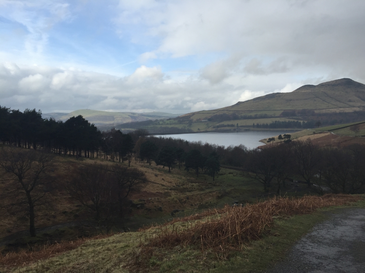
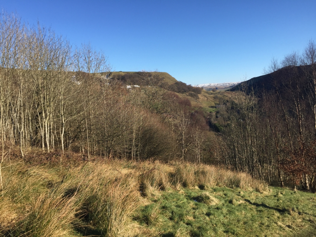
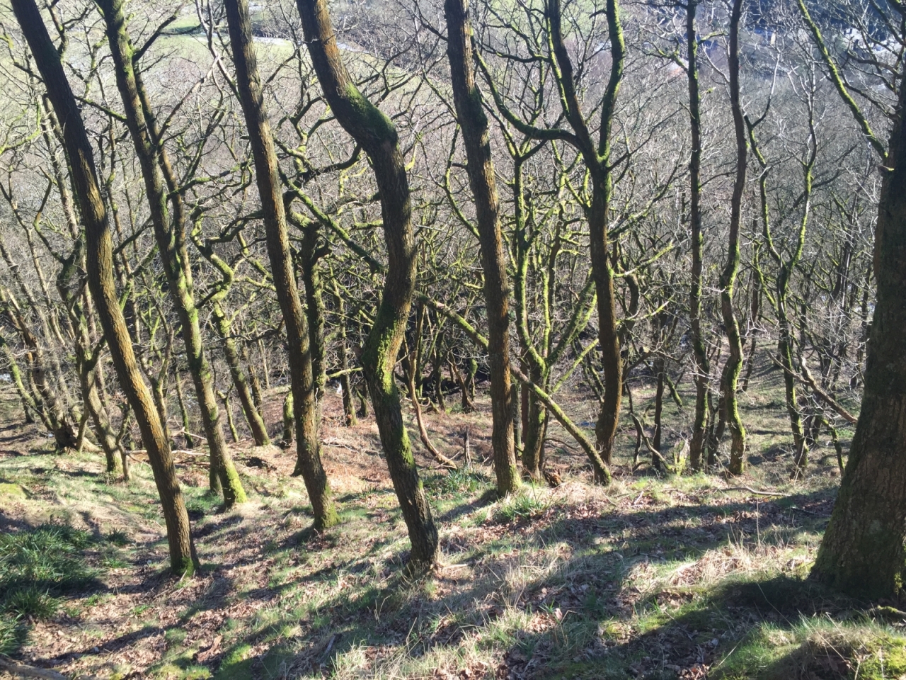
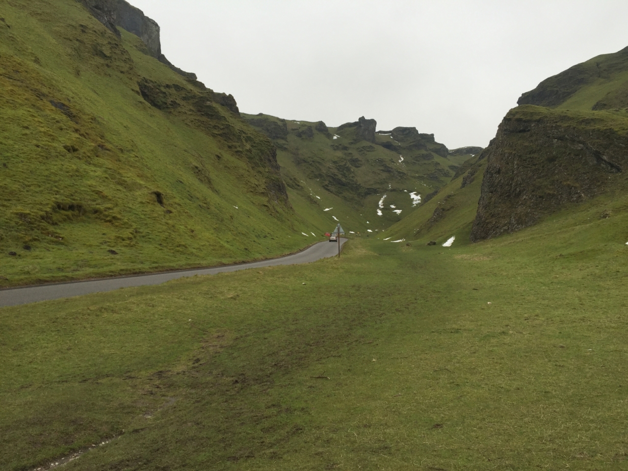
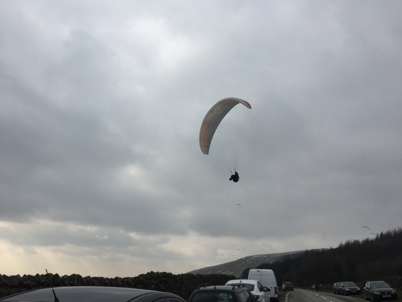
I wanted to share a few things about the experiences I had while over there. All in all, it was a great trip. the first several days were constant rain; there has been historic flooding in the region over this winter and I aw a lot of flood damage across the area. The weather finally broke and we managed to get out and see some of the countryside. One thing I like about England is that they have public footpaths throughout the country. There are marked paths, even through private property, that allow you to basically hike to and from any given point in the country. I spent a lot of time around Tormorden, Hebden Bridge and Dovestone Reservoir for the first week, and then went with a friend down to Peak District. Peak District has some amazing views. While not mountains by most standards, the valleys and views from high points will certainly make you stop and appreciate them. for those interested, there are also a number of caverns that are open to the public as well. Most of the villages and towns there are very touristy; supplies are pretty pricey. This is due in part to this area being the beginning if the Pennine Way. One of the areas we visited was Edele, where the Pennine Way officially begins. there are places to camp but they are strictly regulated; "wild camping" is prohibited, so you have to camp in approved campgrounds. One of the high points for me, personally, was being treated to a large group of Para gliders out around Edele. I spoke to one of them when he touched down and he told me that Edele was one of the best places for this activity in England. It brought out the kid in me, I must say. Well, that's enough for now, don't want to ramble on. Attaching some photos for your enjoyment. Will answer any questions about the trip, just don't want to bore anyone with mundane details.
 3 points
 -
I rarely hike with other people, and I don't carry one for a number of reasons: (1) SPOT-style devices with a "check-in" ability create an expectation that I check in, and an opportunity for false SARs called by others. (2) PLBs are expensive. (3) A PLB is only relevant in the rare situation that you are unable to self-rescue, conscious, able to survive until SAR reaches you (potentially overnight), and in a location with satellite reception (better than cell, but not ubiquitous). (4) PLBs encourage the expectation that you can push a button and a helicopter will show up to save you. Plenty of people disagree, but for me, part of being in the wilderness is being out-of-touch and self-reliant.3 points
-
As this trip was in the planning process we were going to trek 14 miles. We ended up going roughly 9 miles. The terrain for the portion is moderate with some steady inclines and declines throughout it. We started at Prospect road bridge where a 1.5 mile portion of a loop trail (can't remember the name of it) leads to the NCT. We went from there to Jennings Environmental Education Center. The weather was fair enough throughout the day that we actually came across other people on the trail. Some were cross country runners. Others were day hikers. I packed my Kelty RedCloud 90 at 25 pounds with water for the challenge again. For the 9 miles it is overkill so to speak in some peoples opinion. But I am preparing for long distance hikes and I want to see what adjustments I need to make. The views of Lake Arthur are impressive to say the least on this portion of the trail. ( I haven't hiked any other portion in Moraine State Park yet) and I tried to capture some of them with my phone camera. I think my next investment for backpacking is going to be a good DSLR. I had a good time on this trail and it was well worth the 1.5 hr road trip to get there. Once we got off trail we decided to pack on some carbs at a nearby tavern in Butler called Rock Ann Haven. Good food Good Spirits and excellent customer service.
 3 points
 -
Wow, can some of us make a day-hike into a really complicated affair. How about? .... Throw a loaf of bread and a pound of tea in an old sack and jump over the back fence. - John Muir3 points
-
The big negative is having them in your hands all the time, which is annoying and takes away from the simplicity of walking outside. But at some point, early 50's for me, I decided the benefits of staying upright were worth the annoyance. I've had tents that use my poles and like that setup. Let me add to the contention.;) I adjust my poles shorter than most people. Mine are just below waist high. This way I don't do curls all day with them and they are less likey to break. All the mountain guides I've seen keep their's shorter than most non-professional hikers. You should try it. I also get rid of the straps and baskets. Simplicity. Hike your own hike - don't use them unless they make the experience better. Knew you must be local, Gregg. See ya on the trail.3 points
-
This is one of those backpacking topics that really gets contentious. Leather Hiking Boots or Trail Runners?White Gas or Propane? To trek with poles or not? And really, there is no one correct answer - it all comes down to personal preference. Where are you backpacking? Will there be a lot of water crossings? Is there a lot of elevation gain and loss? Are you young or old? What is your physical condition like? My preference happens to be to hike with trekking poles. I don't like the "downs" and having a set of trekking poles I can extend and reach out in front of me helps me navigate descents much more easily. They also help me to stabilize when I'm crossing water. And I can use them for much more than just walking - they can be used to snag a dropped item off the ground (who likes to bend down and pick up something with a 30 pound pack on), or to help set up a dining fly, or even to extend between a couple of trees and hang wet clothes on... If I'm in the middle of a hike and don't want to use them, I just close them down and strap them to my pack.3 points
-
I would suggest not thinking about useful vs necessary as the standard for considering a purchase, but rather risk vs. reward or discomfort vs. comfort. This is basically the decision we make with all of our gear... tarp, tent, or hammock? Inflatable sleep pad or closed cell foam? Cook on a fire, carry a jetboil, or use a pepsi can stove? You get my point. When it comes to trek poles, I believe the reward and comfort factors are significant. In addition to all the features mentioned above, they provide a 3rd (or even 4th) point of contact with the ground, which provides added stability on down hills and slippery terrain. Not only is this safer, but it takes strain off the knees. I personally use 1 trek pole. I like the benefits discussed, and like the freedom of having a free hand.3 points
-
If possible, get an inexpensive pair of ski poles used. Try them out. See if you like hiking with poles. If not, you are not out of much money. If you like them, you can (possibly) get something better.3 points
-
The movie of A Walk in the Woods comes out this week... anyone planning to see it? http://www.walkinthewoodsmovie.com/3 points
-
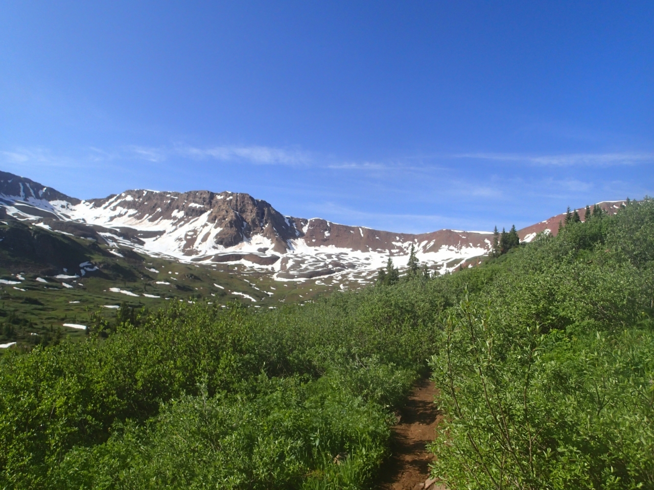
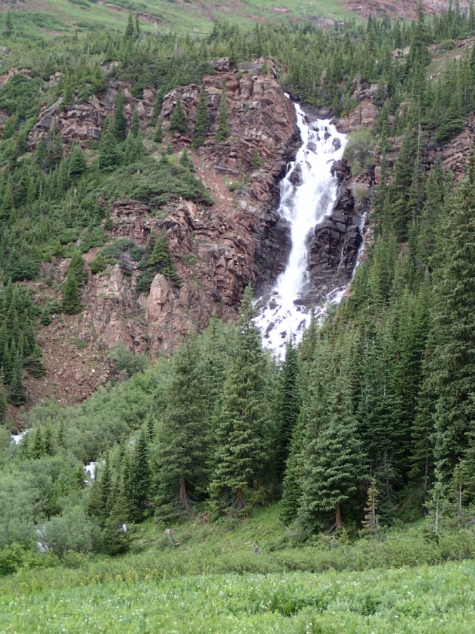
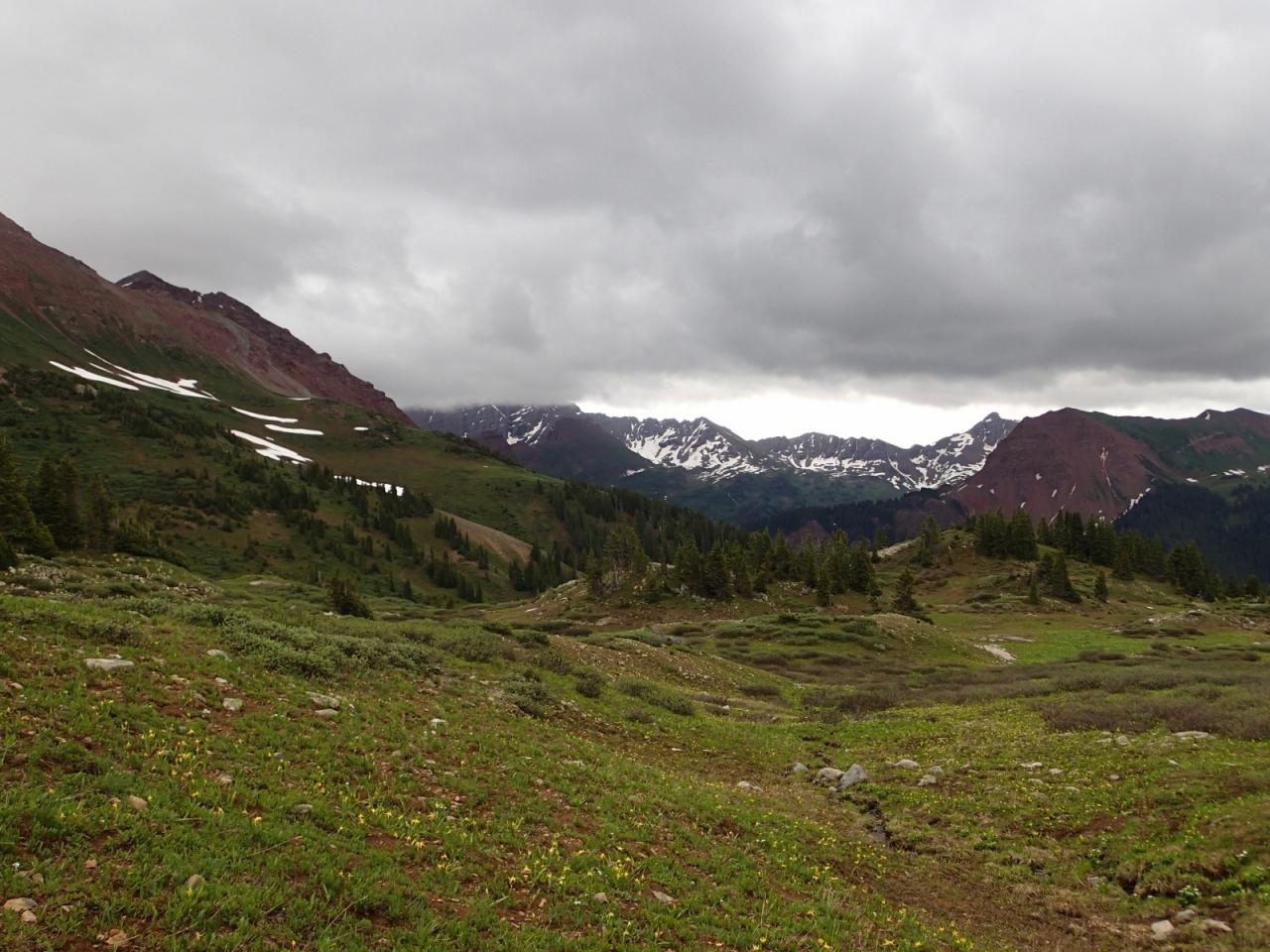
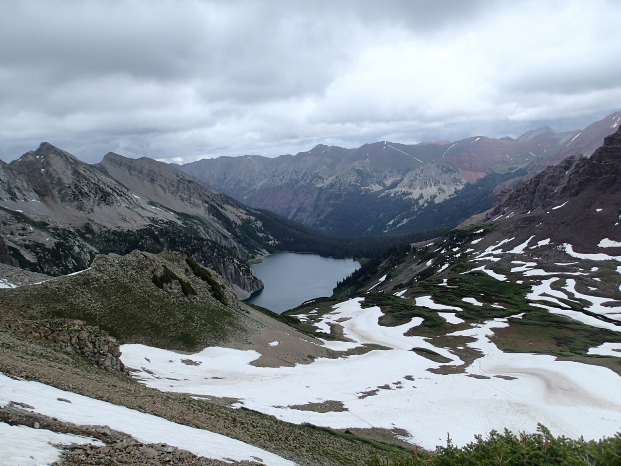
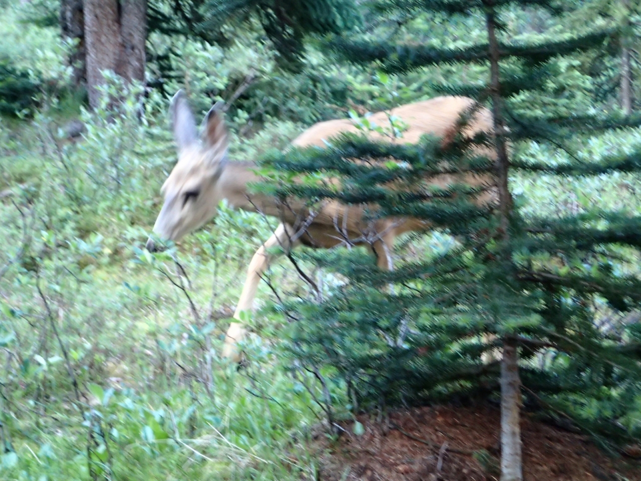
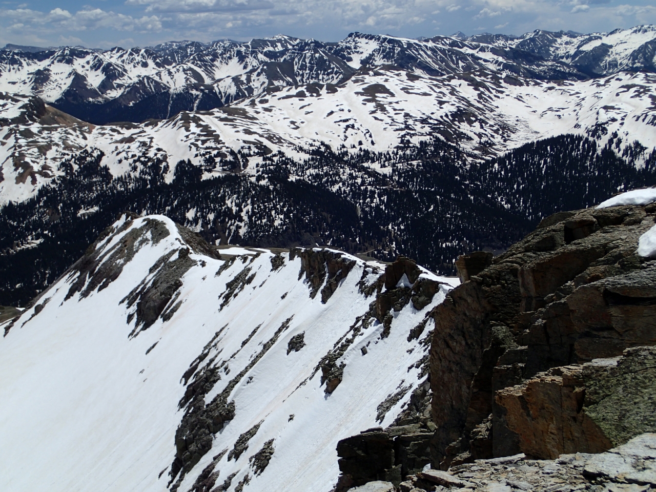
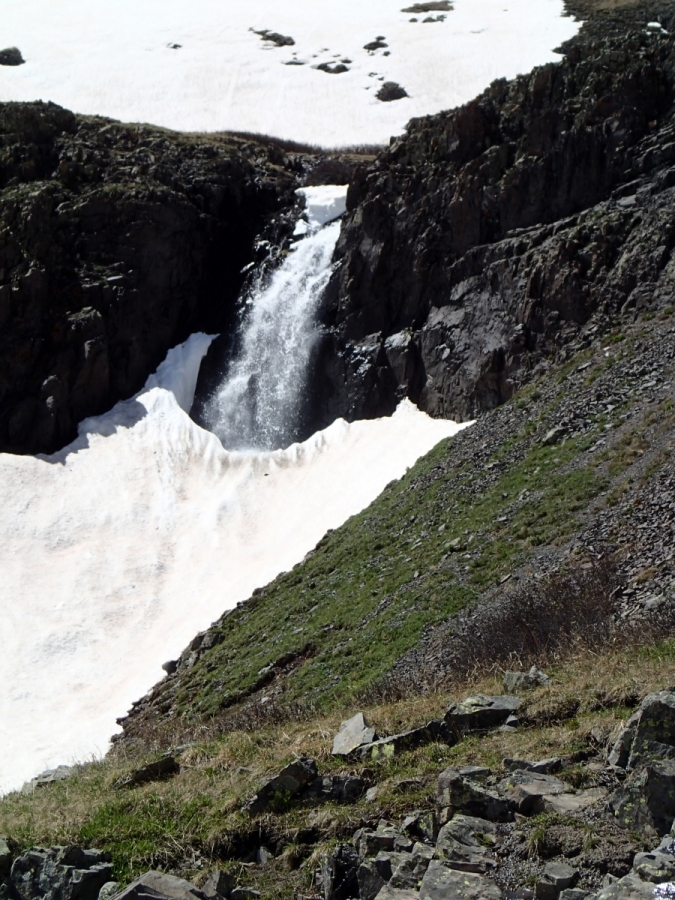
I have been overdue to post this report. I did this 4 day/3 night backpack for the fourth time over July 4 holiday weekend. It entails 28 miles and about 8000 feet of vertical gain and loss over 4 passes as you circumnavigate the Maroon Bells of Colorado's Elk Mountains (near Aspen). I led a trip for the Colorado Mountain Club (myself and 5 others), leaving Friday morning July 3 from the Denver area at 7am, and arriving at the trailhead at Maroon Lake at noon. We had planned to hike up to just below our first pass (west maroon)--about 6 miles and 2000 of vertical. However, we stopped about a mile short of that as the rain was a bit persistent that day: Saturnday (day two) found us up at 6am, on on the trail a bit after 7am--we had a beautiful day, with clear skies, snow capped peaks around us, and (with all the rain we have had in the past 60 days), Colorado was as green as she ever is this time of year: We ascended to west maroon pass, admired the views west into purity basin, then descended into the basin, back up to our second pass of the trip--frigid air pass. All four passes on this loop are approximately 12,500 in elevation. Snow was present on all the passes, but it was easy to avoid or deal with the terrain. After lunch and some hang time at frigid air pass, we descended into fravert basin and then another 3-4 miles to our camp for the night. We arrived about 3pm. I like to do this trip over 4 days so that each day allows for an early arrival to camp, and time to chill, relax and enjoy the scenary (after our chores are done, of course!). We had a bit of rain shortly after setting up camp, but nothing like day 1. A good sized buck mule deer decided to stop by and check us out after dinner, but his visit was very brief, and my camera wasn't quite handy enough. Sunday (day 3) found us on the trail around 7:30am. This was our hardest day, with a steep climb out of fravert basin up to trail rider pass. We did have a treat to start the day--views of a 300 foot waterfall (King falls). After a bit of a climb, there is a beautiful alpine meadow with views to the backside of the maroon bells, and a small lake--one of my favorite parts of the trip. We ran into some rangers doing trail work as we were sweating our way up to trail rider. They informed us that most likely by next year bear boxes are going to be mandatory for the entire loop, rather than just the lower part of west maroon creek drainage as was the case this year (day one terrain). This doesn't excite me. In any event, trail rider was our lunch spot, and we again admired great views down into snowmass lake, and also of many of the surrounding elk mountains: hagerman peak, snowmass peak, snowmass mountain, maroon peak, north maroon peak--the list goes on! We then descended to snowmass lake to camp for the night, encountering the largest snowfields of the trip, but consolidated enough that it wasn't a problem. Arrived to camp early afternoon. Had heavy rain shortly after arriving, and had to resort to shelter in our tents until it let enough to allow for dinner. Rain, thunder, and lightning most of the night! Monday (day 4) up at our usual 6am, had the joy of packing up wet tents, but the rain had stopped, and held off all day to allow for an enjoyable hike up to our final pass (buckskin), and then a descent back to our trail junction near crater lake. There we rejoined the hordes of tourists, who generally will hike this far, and no further. Back to maroon lake, where we caught the bus back to aspen highlands (just outside of aspen, where we had had to park our vehicles). I saw more folks on the four pass loop this year than ever before--I suspect this is driving the forest services' decision on bear boxes. All in all, a great trip! Here's a link to all pictures, for those who are interested: https://picasaweb.google.com/102393818060897668441/4PassLoop072015 Enjoy!
 3 points
 -
One of the premier backpacking destinations in the Midwest. The Porkies - Located in Michigan's Upper Peninsula - has trails spread across its 60,000 acres, offering hikers plenty of choices to keep things interesting. Here's our look at the park from Issue 1: Porcupine Mountains Wilderness State Park in Issue 1 Backpacking in the Porcupine Mountains: A Quick Guide - Republished on the TrailGroove Blog Issue 1 Page 1
 2 points
 -
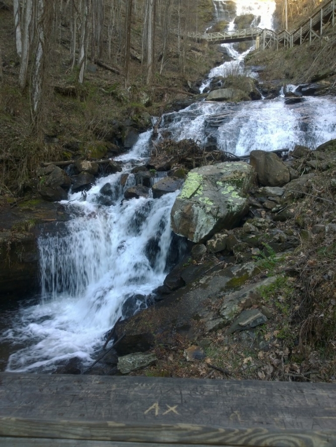
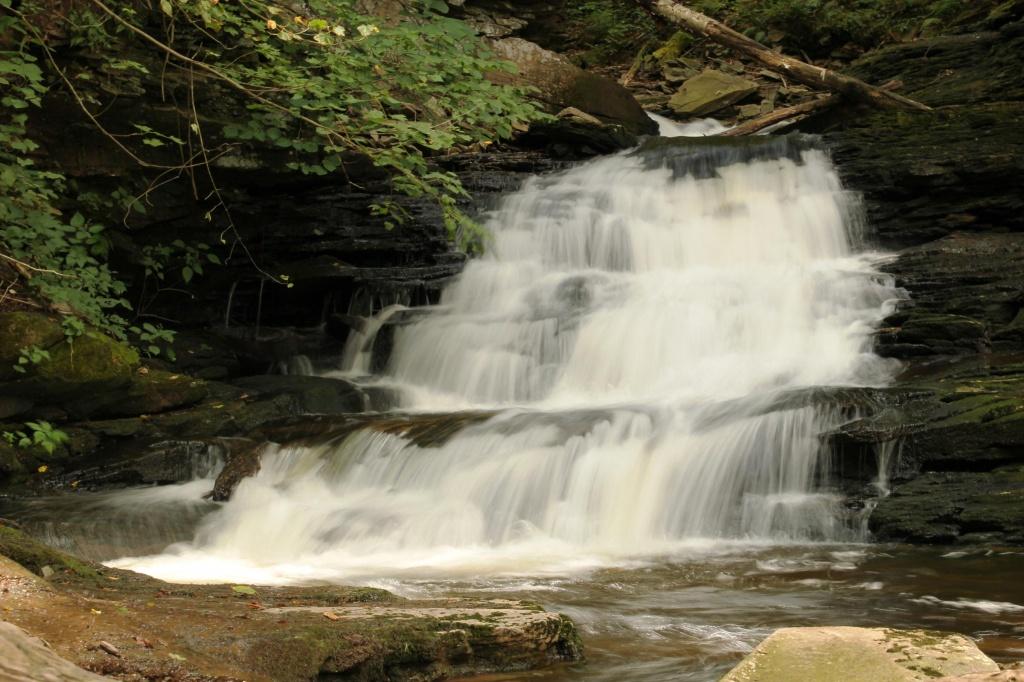
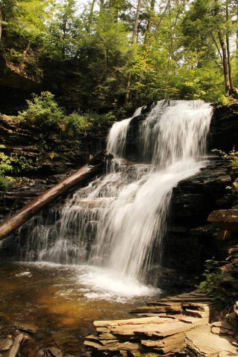
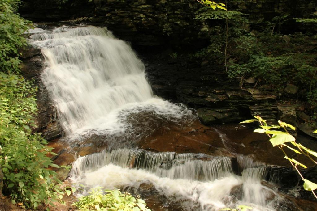
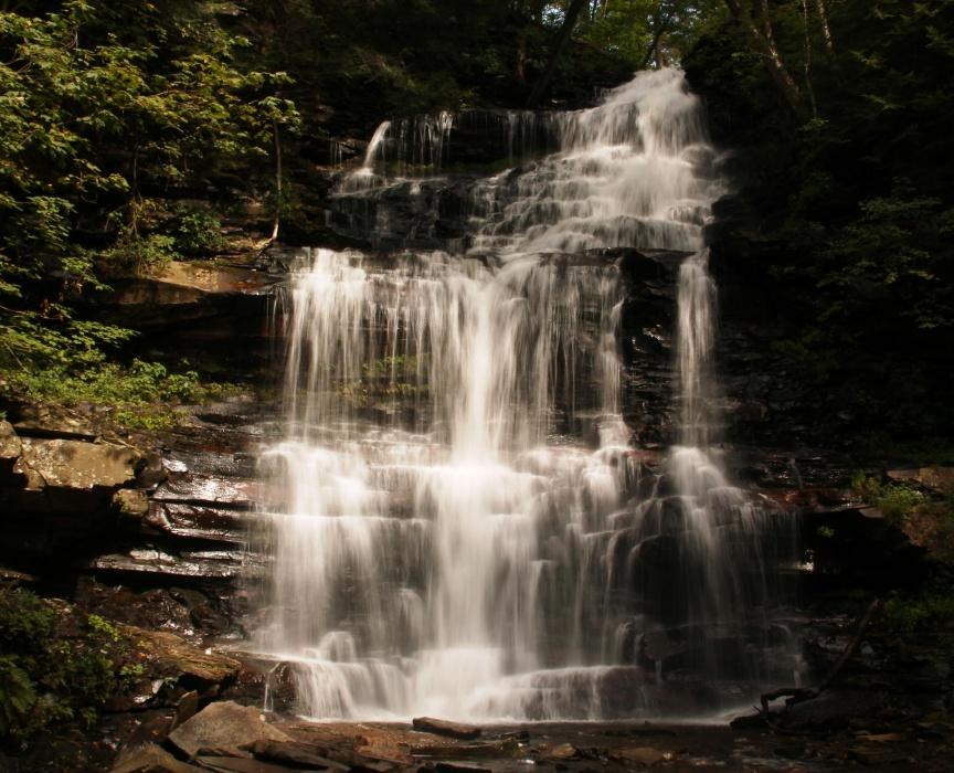
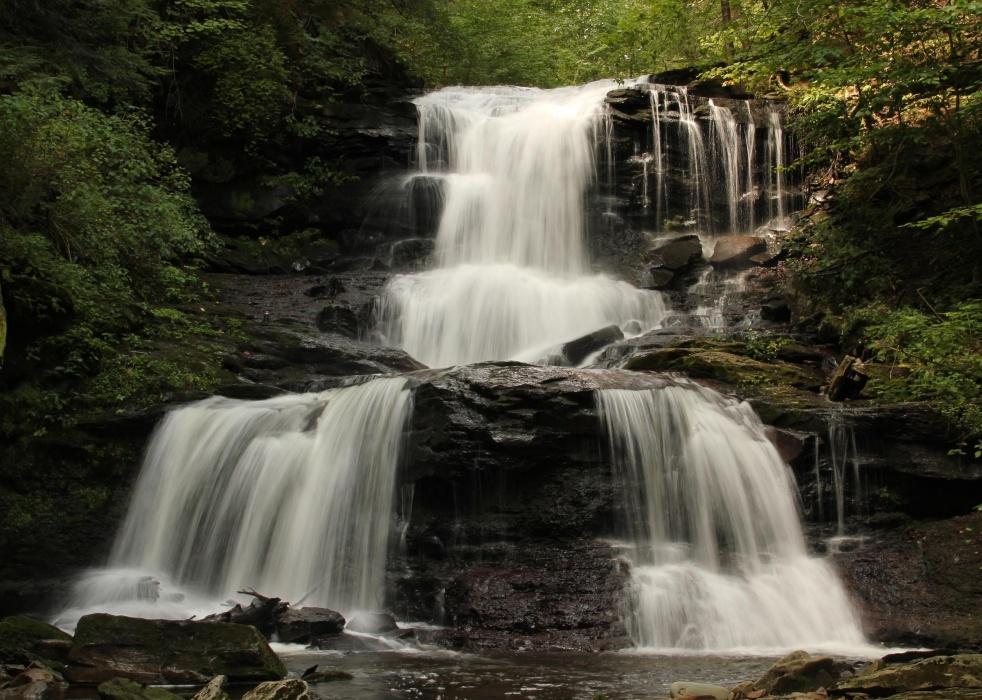
Ricketts Glen is a State Park in Pennsylvania and also a National Natural Landmark, known for its old-growth forest and 24 named waterfalls along the Falls Trail of Kitchen Creek. Ricketts Glen resides within 3 counties (Sullivan, Columbia, and Luzerne) and is accessible most easily via PA Routes 487 or 118. There is no camping along the Falls trail as it is for day use only. However, there is a large campground in the State Park. Here are a few photos of some of the spectacular waterfalls. If you are planning on checking out some places in Pennsylvania, Ricketts Glen is not to be missed. Delaware Falls Shawnee Falls Mohican Falls Ganoga Falls Tuscarora Falls
 2 points
 -
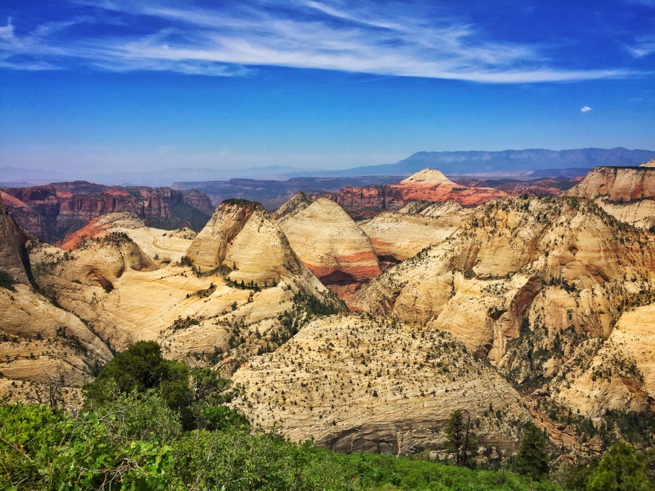
Hi I've been an active member on backpackinglight.com but finally paid for a membership on Trail Groove. :-) I live in Los Angeles and try to do a few overnight local trips and 1-2 bigger trips also each year. This year I was lucky to hike the Trans Zion Traverse in June and then thru hike the JMT in July along with local trips near Santa Barbara and San Gabriel Mtns.
 2 points
 -
Recently hiked the 161 mile Collegiate Loop around the Collegiate Peaks of Colorado. A great alternative if you don't have time for the entire Colorado Trail following both the Colorado Trail and Continental Divide Trail/Collegiate West with miles of alpine travel above treeline. The trip report and photos are at my blog link below. http://tomcatoutdoors.blogspot.com/2016/08/backpacking-collegiate-loop.html2 points
-
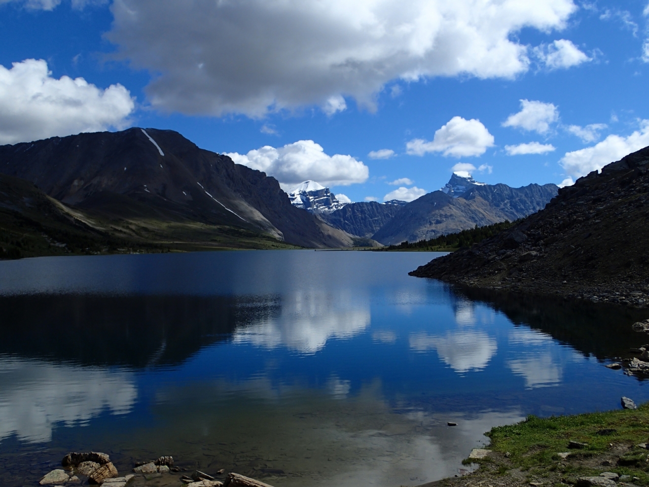
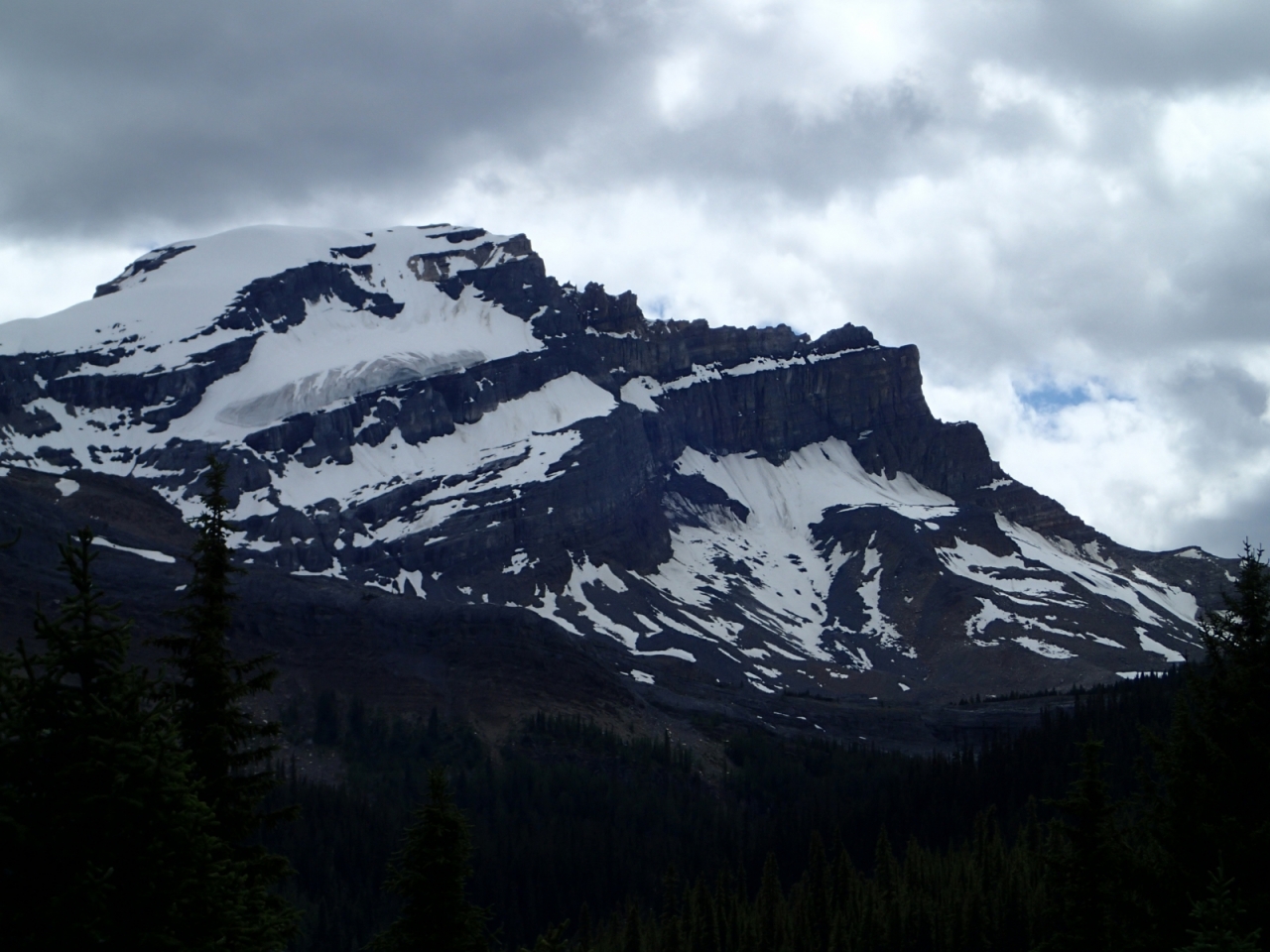
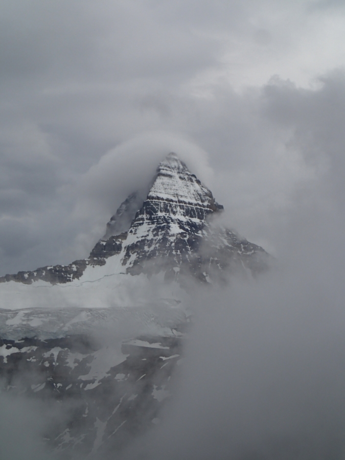
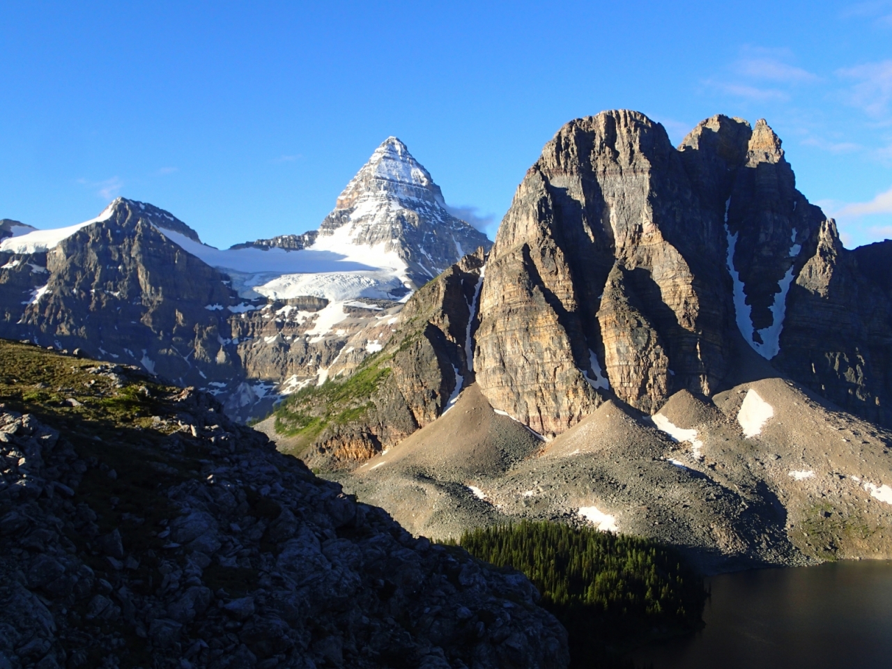
I just returned from a two week backpacking trip in the Canadian Rockies (the parks west of Calgary between Banff and Jasper). This was my eighth trip to the area since 1995. If you have never been, you need to go! The canadian parks system has made it much easier to reserve front country campsites, which can be done thru their website at: www.parkscanada.gc.ca. I have found that backpacking trips (for me) are much more fun if doing them as a series of "mini trips" of 3-4 days followed by a quick break for laundry and shower. Guess I'm getting older and still like some creature comforts. Thus, myself and friends planned (3) goals on this 2 week valley: 1. Skoki Valley, an area just east of Lake Louise, accessed from the fish creek trailhead. The best maps for the canadian rockies are from GemTrek publishing--they can be found on Amazon. After flying in to Calgary on Sunday July 17, we got a rental car, and arrived that afternoon at the Lake Louise frontcountry campground, and slept among the tourists. Monday the 18th found us at the fish creek trailhead by 8:30am, and the start of 4 days and 3 nights in Skoki Valley. Back country permits were required for all 3 areas we visited on this trip--they can be obtained by calling the park 3 months to the day ahead of the date you are targeting. We had a fairly easy hike in to our first night camp at Baker Lake (about 1800 of vertical and 8.5 miles) . We had a bit of rain and muddy trails the first two days, but things improved on the last two days. Did a great circle route, staying at Baker Lake the first night, Red Deer Lakes on second night, and Merlin Meadows on third day. We took a side trip on day 3 to the Skoki lodge (back country lodge where we were able to obtain a light lunch including some carrot cake to die for!). Also took a side jaunt to Merlin lake which was well worth the trip. Came out on the 21st, and got showers and laundry at Lake Louise--we much prefer this area to the town of Banff for back country needs--the Samson mall there has: small grocery, 2 restaurants, gift shop, outdoor shop (where fuel and bear spray can be obtained), along with a parks center and bookstore. There is also a liquor store for those who imbibe. Stayed at Lake Louise campground the night of 21st, then on to our second goal on the morning of 22nd: Mt Assiniboine. As the hike in is 14 miles (one way) we chose to take a helicopter in and out as a time saver. While I am retired, and time isn't an issue, my friends are not. There is a backcountry lodge at Lake Magog for those who prefer luxury. We chose the campground at the far side of the lake for the next two nights. I will mention that all of the backcountry campsites we stayed at have bear hangs for your food, which is appreciated. We saw rain the afternoon and evening we arrived, and also the following day. Not deterred, we hiked up to a local viewpoint of the area's major attraction (Mt Assiniboine). However, all we got was views of the clouds, and the lower half of Assiniboine. Sunday morning dawned finally with good weather--blue skies and hardly a cloud. Our copter flight out was at noon, so we were up and on the trail at 6:30am--headed back up to a local ridge called Nub peak where beautiful views Assiniboine can be had in such weather--got some amazing pictures, scurried back down to our camp, broke camp and hiked back to the other side of the lake (where the lodge and helipad are located)--arrived 15 minutes before our flight out! That night (24th) found us back down near Banff at two jacks front country campground--got showers and laundry done again. The 25th we were off to our third goal: Goodsir pass and views of Mt Goodsir. This entailed a 9 mile hike in to helmut creek backcountry campground, where we stayed the next two nights. Got in a quick hike up to goodsir pass the day we hiked in, which made it a 15 mile day-good fund?! 26th found us hiking back up to goodsir pass, and then to a local/unnamed peak at 8100ft elevations--the weather was perfect for us, as was the view of the Goodsirs (they have a north and south tower of the peaks, which are considered separate peaks). Both towers are over 11,000 feet--the Canadian rockies have 54 11ers, coincidentally the same number as there are fourteeners in Colorado, my home state! After hanging out for several hours enjoying the 360 views of nothing but incredible canadian peaks, we were back at our campsite for the second night. Hiked out on the 27th, again got a front country campsite near Banff, and showers (I'm sure the folks on our return flight to Denver appreciated that). Got our flight back to Denver on the 28th, arriving safe and sound after a perfectly executed trip! Here are some pictures. Complete pictures at: https://picasaweb.google.com/102393818060897668441/6312898319211612785?authuser=0&feat=directlink
 2 points
 -
Kay-Hikes; One of the most refreshing things for me on a hot weather trip is to dip my hat or bandana in a cool stream. Fantastically refreshing! Also nice to take off your hiking shoes/boots and cool off your feet. Sometimes the best things on the trail are absolutely free. Try it and see if you agree.
 2 points
 -
@Gary M Great suggestions! I had heard on a hiking guide somewhere online that pre-hydrating can do a lot for staying hydrated on a hike, and that one should aim for 16 oz. of water every hour during the hike. I'm guessing that may be more in hot weather, but either way that seems like a lot of water to carry! Also, I hadn't considered that feeling thirsty would be an initial sign of dehydration, but you're absolutely right. It'll probably be best to keep on a water schedule of sorts instead of depending on my body to tell me when I'm thirsty. The hat is a great suggestion too! I usually opt to not wear a hat for fear of trapping heat on the top of my head, but it would be something worth looking into. @Aaron Thanks for the link! I'll definitely check that out!2 points
-
Kay-Hikes; 1st suggestion.............. Start hydrating several days before your planned hot weather hiking/backpacking event. Drink plenty of liquids (plain water is fine) with little or no caffeine drinks such as pop. When on the trail, pack and drink lots of water. If you wait till you're thirsty on a hot day, it's too late and you are already dehydrated. It's a very common mistake that new hikers/backpackers make; underestimating the amount of water needed in hot weather to avoid some very unpleasant problems. Gary M 2nd suggestion............. Wear a wide brim hat for sun protection. If you search the TrailGroove archives, you may see I'm a Tilley fan. Don't let looks fool you or allow vanity convince you otherwise. A quality wide brimmed hat could save you from heat stroke or skin cancer. Neither is anything you want to mess around with. Gary M (from the vast plains of Kansas)2 points
-
Definitely a confidence booster for my navigation and off-trail travel - it was a great time! Although I wasn't especially productive Monday with less than five hours of sleep...2 points
-
This was a great trip and it was great to get out there and successfully explore the length of this range that's always caught my eye when driving by in the past...a surprisingly isolated place - but I think we got to know it pretty well over the weekend. @HikerBox @markt1962 Thanks for the report Paul!
 2 points
 -
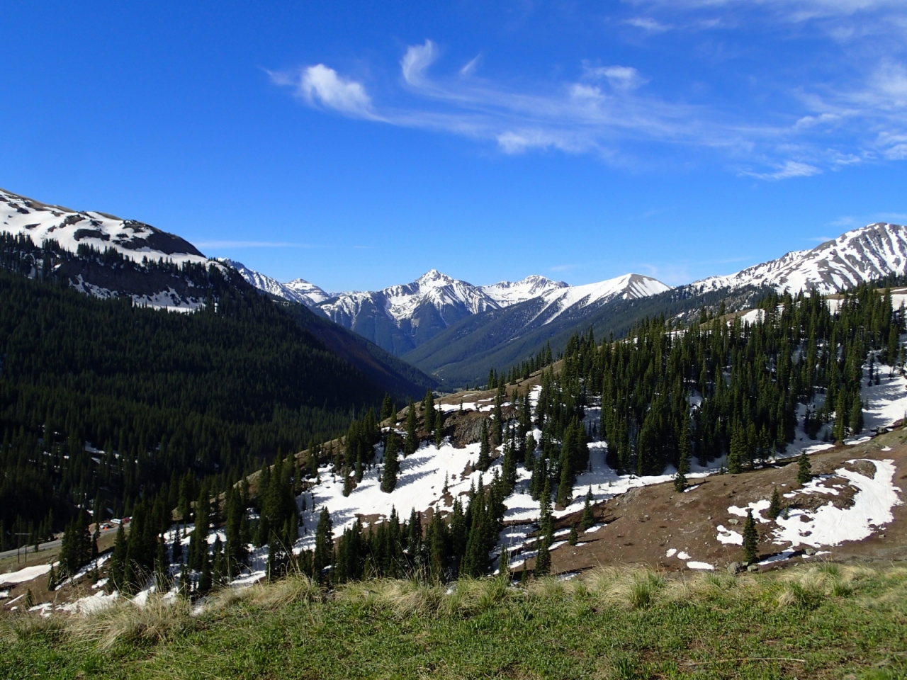
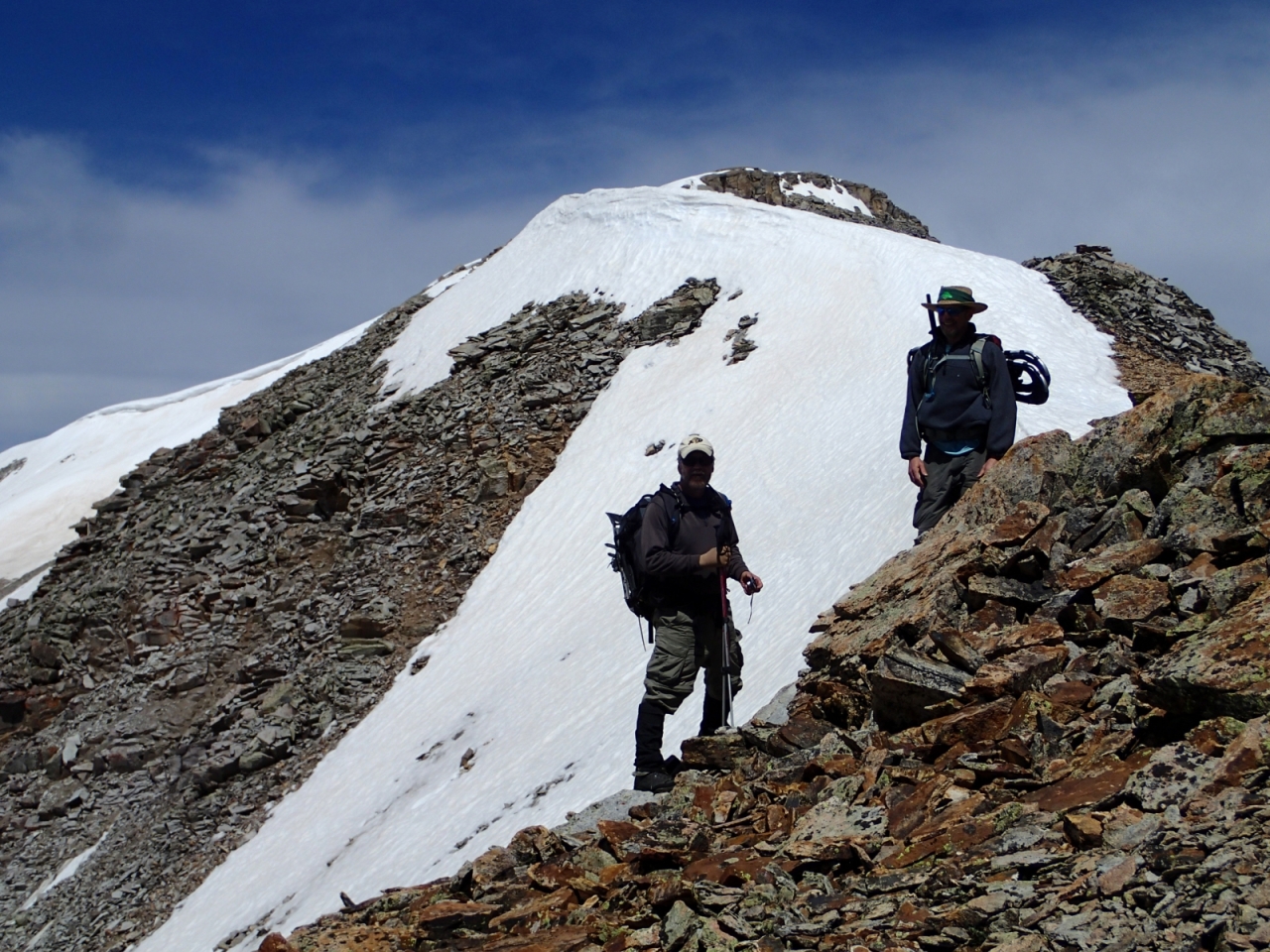
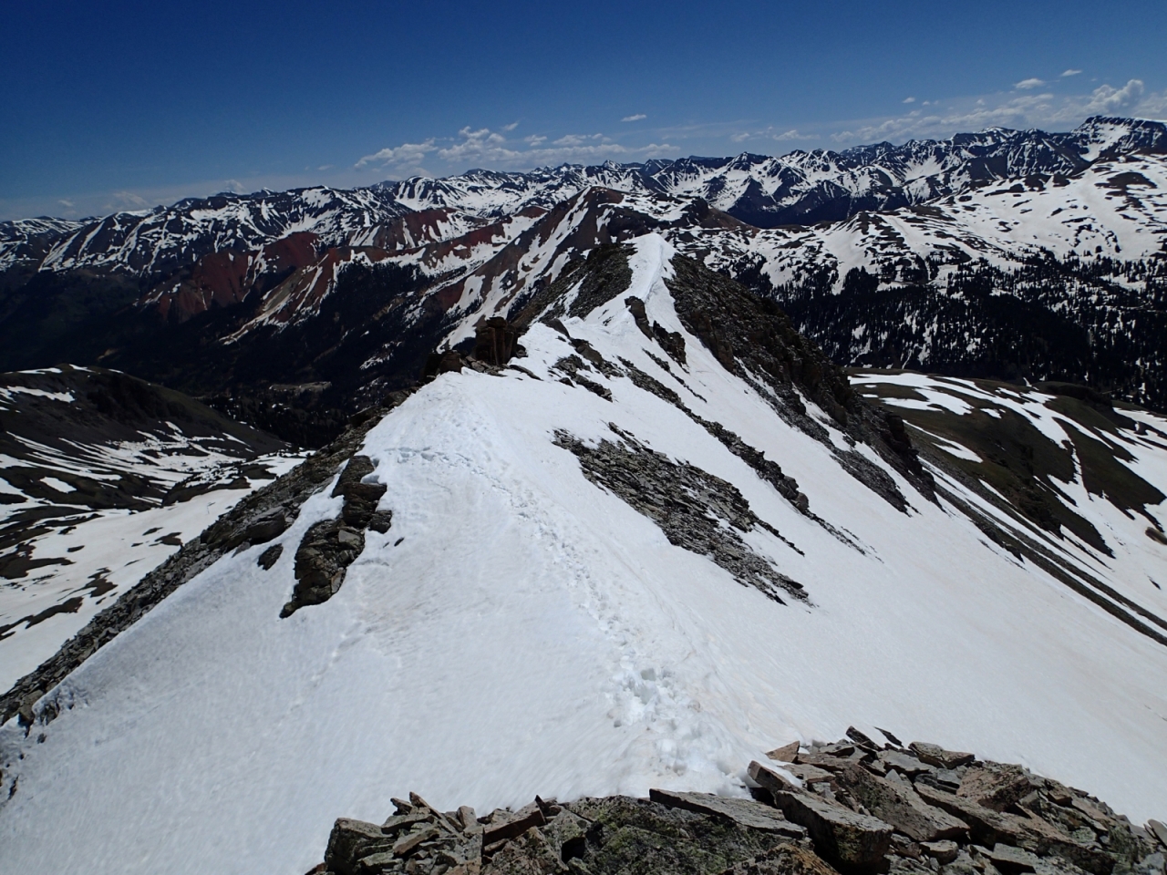
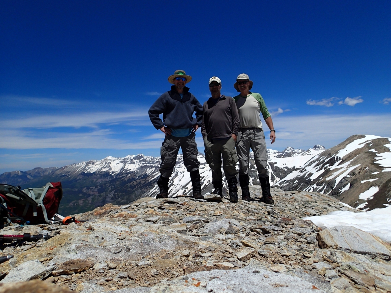
It has been a bit of a longer wait than usual for snowmelt in the Colorado mountains. I was able to finally get out to do a climb of Trico peak (13,321ft) with my brother and a mutual friend of ours this past Friday. This peak is located in the San Juan mountains between Ouray and Silverton, conveniently just west of red mountain pass. Still had to deal with some snow (snowshoes were required in a few spots), but the bluebird weather and unmatched scenery made it all worthwhile.
 2 points
 -
My wife and I took a day trip up the South Boulder River last week out of Cardwell, Montana. We had two goals: 1) to hike up to a pond a little over a mile south of the old mining town of Mammoth (on FS Road 107), and 2) hike up the East Fork on FS Trail 7154 until we found the snow line. Well, actually, there were three goals. The third being to determine if there was enough of my elderly body left to still do this stuff. The hike to the pond was off-trail and about a 1000' elevation gain in a half mile, with some serious bushwhacking thrown in. View up South Boulder from below Mammoth. Middle Mountain from above Mammoth. We hit the wildflowers near perfect. Calypso bulbosa. Fairbells-Disporum trachycarpum. Glacier lily. Erythronium grandiflorum. In some places, the ground was totally covered with these. The stream downhill of the destination pond. The hiking buddies. View west across South Boulder River on hike to pond. Pond outlet. Pond. Alas, no fish but we didn't really expect any. However, it would seem sufficient to support a population of cuts and most certainly would support brookies. Another view west across the valley. Missy. Shooting Star, probably Dodecatheon pulchellum. Looking southwest, probably part of Jackson and Lakeshore Mountains. More Calypso. Back at FS 107 and the faux Jeep. South Boulder River. Pasqueflowers, Pulsatilla patens, near the trailhead for FS 7154. East Fork Boulder River. Some call this Blaze Mountain but officially, it isn't named. Home brew Wilfley table? Remains of a miner's cabin. A very well aerated East Fork. Looking west from 7154 above the first headwall. There were a lot of deadfall on the trail. FS Trail 7154 near the end of our hike at about 7,800'. The snow was totally rotten and we were getting wet feet even in the intermittent piles. Granite Peak (10,590') in background.2 points
-
I hiked the NJ AT a couple of years ago from the Water Gap to High Point. Just looking at my maps, I think the only camping restriction was in Worthington State Forest where the only backcountry camping is at the intersection of the AT and the Douglas trail near Sunfish Pond. I made notes on my maps of potential campsites in the Delaware Water Gap and the other Forests. I know I camped at a non-designated site the first night and at a shelter the second night. I had a hammock which was the only reason I was able to camp where I did the first night, a tent would not have worked. If you are really worried, I'd contact http://www.nynjtc.org/region/appalachian-trail Hope that helps.2 points
-
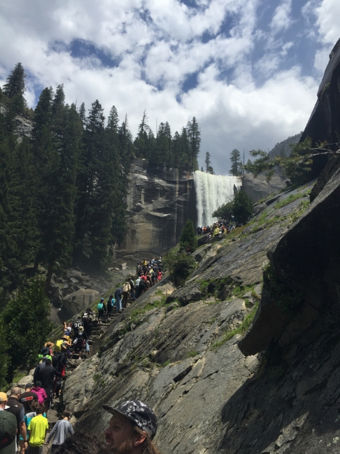
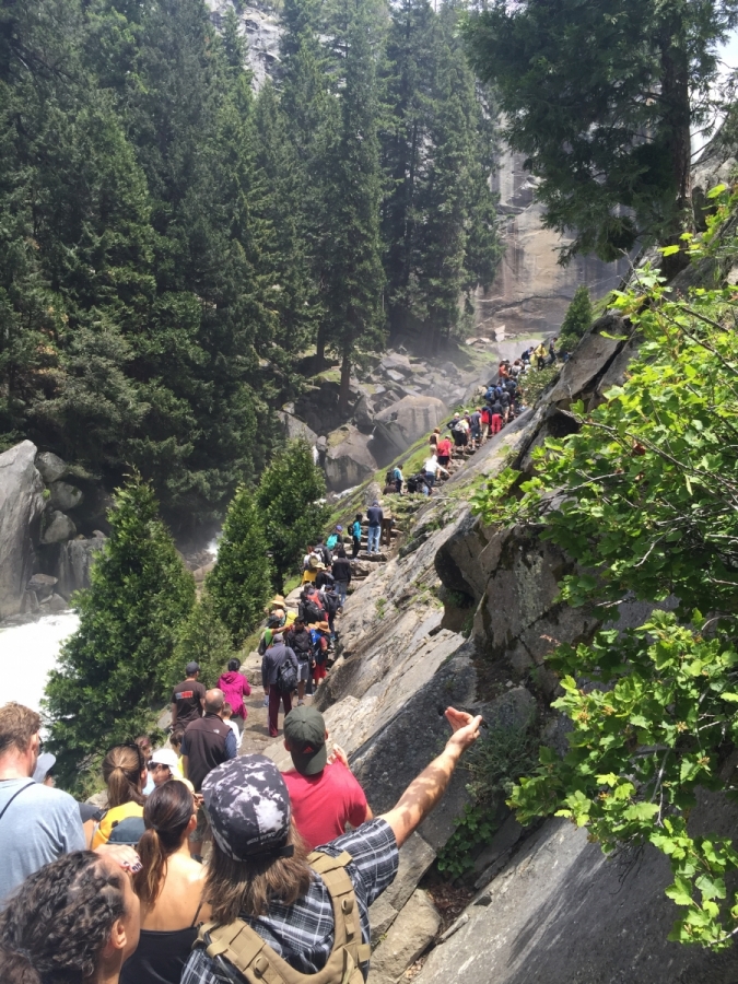
Hi I replied to you last night but for some reason it never posted.... So this post has my name written all over it. I too was a first timer in Yosemite last weekend-Memorial Weekend. Despite everyone telling me how crazy I was for choosing to book this trip this on such a busy weekend- I am glad I did. I have always always wanted to go to Yosemite and I finally got to check it off my list! We reserved a campsite in Lower Pines, the valley is definitely crowded but this campsite was nice, and people were respectful, I noticed other campgrounds were a little more compact, this was perfect for us. Traffic was crazy in the valley, we rode the shuttles everywhere but still had a hard time getting around because the shuttles were stuck too. Be prepared to wait. We stayed only 2 nights, arrived Saturday and checked out Monday and because of that we decided to go on the Mist trail. It was pretty cool except the crowd factor. Once you got to the wet steps up near Vernal falls, you took one step every few minutes. It would have been better if you just had a straight shot up to the top, and stopping on every step made you contemplate your surroundings, get dizzy etc..Going up you had a rock wall to hold onto and allow others to pass going down. I was worried people were going to fall into me and knock me over because going down they didn't have anything to hang on to. And people were dragging babies, toddlers and kids down with them, which I thought was pretty stupid, but I am not a parent, I don't have that judgement. But the trail itself is pretty decent and I think the people just make it harder than it is. But once we got to the top it thinned out and the higher we went, the nicer people were and it was more spaced out. We took went straight up to Nevada Falls to the very top and took the Muir loop back down. I would have gone back down those wet steps if it wasn't so crowded. The trail itself is grueling, I suggest some conditioning before hand if you decide to go. The elevation change and the distance going straight up to the top of a waterfall is very challenging if you are not fit or not used to it. I also suggest very good hiking boots, I saw some women with sandals, and then someone said they saw someone barefoot. But we hiked with some friends and despite not having any trail experience lately, they made it, they were cursing the way down and yes muscles were sore and feet were on fire but they said it was worth it, we all said that. I think 2 days was not enough, I think it was just as bad as only having one day there. I wanted to go to Glacier point, Illouette falls, bridaveil falls, and explore up by Tioga and possibly hetch hetchy. And we decided to go this time of year because of the waterfall flow. But overall if you decide to go that weekend, just have patience, expect it to be crowded and most of all have fun. I don't regret going last weekend, it was a great kick off to summer despite how crazy the crowds were, I got a lot of awesome photos, hang out with friends and enjoy it. I hope you do the same!
 2 points
 -
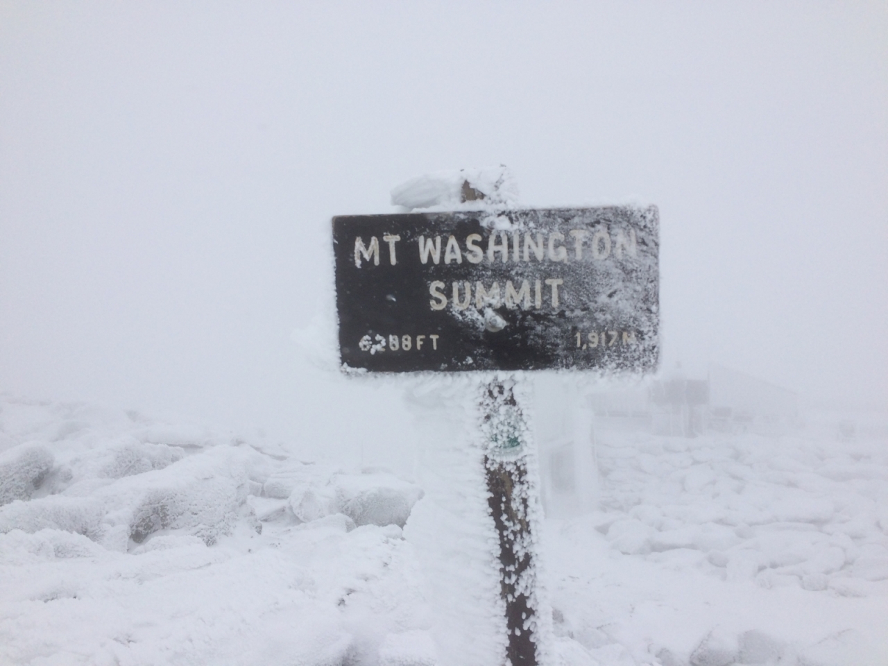
Winter in October, brought to you by Mt. Washington The coffee at 5:45 that Saturday morning resembled dish water and failed in its job. I had slept poorly, trying to stave off the early signs of a bad cold on a day that I needed all the energy I could muster. My 17-year-old son Henry told me that I had snored all night long and as a result he also got little shuteye. It was October 17, 2015, and for two years Henry had begged me to climb the fabled Mount Washington in New Hampshire. Hiking a mountain that days earlier was the coldest place in the continental U.S. was not appealing, especially when the weather three hours south in metro Boston had been in the balmy 60’s for several weeks. In fact, I’d been putting this trip off – and dreading it – for too long. Years ago, I had hiked the mountain twice in February with friends, using rented equipment from EMS along with their expert guide. We summited once and I told myself never again, especially in winter. This time was different with me as the responsible one. It was time to face the mountain. With an elevation of 6,288, Mt. Washington is the highest peak in the Northeast and the eighth most dangerous mountain in the world, according to GearJunkie. No wonder, with the highest recorded surface winds on earth of 231 mph. We were guaranteed to experience some of that force today. After leaving our 1750’s-era bed and breakfast (sans the breakfast) in North Conway, NH, we began hunting for sandwiches to accompany our other snacks for the hike. As I sipped my bland Dunkin’ Donuts coffee, we came upon a small country store with wraps. Perfect, except that they were in huge plastic containers that got crushed when stuffed into our compact packs. Sustenance was crucial so we made it work, sort of. Our goal was to start hiking by 7 am, and reach the summit. We pulled into the Pinkham Notch welcome center and signed in so the rangers knew we were official hikers. Two inches of snow had fallen at 4,000 feet the night before, and another 2-3 were expected during the day. Winds were gusting to 60 mph, and the temperature was 20 degrees at the summit. Wind chill was somewhere south of zero. This is October? Ugh. “Do you think reaching the summit is doable today?” I asked one of the wardens, hoping that she would advise against it and we could hike for an hour and call it a day. “If you’re careful, yes. But the weather is very fluid up there,” she said. “Do you mean fog and snow and wind?” “Yep, all of it.” Great, I thought. “OK… and if all goes well, how long do you estimate it will take to reach the summit?” She hesitated, looking us over and said slowly, “Well, that’s tough to say, but generally it should take about four hours, give or take.” We purchased a map and put boots on the Tuckerman’s Ravine trail at 7:15 am. Frozen mist and temperatures in the mid-30’s confirmed that we did not overthink our clothes. We had planned our gear very thoughtfully for this day, making sure there was not a stitch of cotton touching our skin. When wet cotton sticks to the skin it slowly reduces body temperature, which can lead to hypothermia and in some cases, death, especially on this mountain. According to appalachiantrials.com, more than 130 people have died on Washington since 1849, with many cases resulting from poor judgement, inadequate equipment, and bravado. Our several layers were designed to be stripped off when we got too wet or overheated. Our boots were standard good-quality hiking shoes with no crampons. We were dressed ready to hit the ski slopes in very cold conditions. The Ravine trail is the most popular of the bunch that web their way up the mountain. Its 4.2 mile trek to the summit is a gradual incline the first few miles; wide and not too steep. But rocks the size of recycle bins that litter the trail can be hazardous. Just off the trail about 15 minutes in, a beautiful waterfall called Crystal Cascade provided a nice diversion from what lay ahead. We decided to take the Lions Head trail that splits off the Ravine trail about .3 miles from the Hermit Lake Shelters. Lions Head traverses steep and narrow up the right side of the ravine, and is the less treacherous option to the top of the ravine. At this point I was taking many breaks, and couldn’t keep up with Henry who is a third my age. I kept hearing, “c’mon dad!” As a rower, he’s in top shape and could probably run up stretches of the trail. I reminded him several times that most dads I know would rather be swinging a club than step foot on this mountain. Off came the layers. One of my four was drenched and I wondered if that was normal. I still had three on and started unzipping to ventilate. Our first fellow hiker of the day appeared about half-way up Lions Head. A French Canadian, he was decked out with state-of-the-art hiking gear including professional hiking boots and crampons, along with hiking poles strapped to his pack. He looked like a fit guy out for a little stroll up a hill. We exchanged small talk while I stuffed my soaked layer into my bulging pack, trying to prevent my large sandwich container from falling out. He wished us luck and headed into the clouds above. As we neared the top of Tuckerman’s Ravine, we came upon a young couple with a Chocolate Lab. Almost more remarkable than a dog this far up in these conditions – 25 degrees and gusting close to 50 – was seeing a guy with shorts on. We said a brief hello as we passed. The shorts might have done them in, as they never appeared again. The ridge top was the first glimpse of the lunar landscape that would dominate the rest of the hike; increasing winds, limited visibility to about 100 yards and the start of the infamous rocky floor with about 3 inches of fresh snow blanketing, and hiding, hundreds of small crevices. At that point, we both thought separately about turning back. But two years of hope and hype and being in the present moment won out. About 200 yards from the top, we saw our Canadian friend on the way down through the fog and asked how much farther. “You’re almost there, only about 10 more minutes,” he responded. “Anyone up there?” “Nope,” he said, as he disappeared. Cresting the top where the trail head meets the bottom parking lot was surreal. No cars anywhere, no humans, no life. Because of the snow, the seven-mile-long access road was closed, which was unusual for October. An eerie feeling swept over me, knowing that we were truly alone atop the highest peak in the Northeast. It resembled pictures I’ve seen of the Antarctic. I looked at my phone; it was 10:45 am – we made it up in 3.5 hours. I wanted to stay together, but Henry was a kid in a candy store, bounding around and soaking it in. I lost him for a few minutes, calling out his name against the fierce wind before his blue shape came into view. We were starving and found a shallow doorway in one of the many old outbuildings to grab lunch. The ironic “sorry closed” sign on the door partially covered in snow gave us a laugh. After a 10-minute lunch, we cruised around a bit more, and came upon a large building that looked like a welcome center. A beefy pickup parked outside covered in snow came into view. Maybe we weren’t alone. We entered the building and found Tom. He was sitting in a chair near the entrance; dry, warm and looking comfortable, drinking coffee and smoking a butt. I envied him, for a second. “Hi, we just hiked up. What crazy weather out there,” I said. “Yep,” replied Tom. “Glad I took the truck.” I smiled. “What is this place,” asked Henry. “It’s the Sherman Adams Visitor Center, but we’re closed now,” said Tom, who said he manages maintenance projects for the clump of buildings on the summit. “You can walk around and use the bathroom if you want,” he said, ending the sentence with a long drag. We both used the men’s room and tried to dry our gloves with the blow drier. I wanted to get down by mid-afternoon and wasn’t sure about traversing the rocky minefield again. Tom said we could walk down the 7-mile access road but it would take longer, and it just seemed too pedestrian. We were refueled from lunch and the soreness was manageable so we headed for the trail. As we exited the visitor center, two more intrepid souls came in to warm up. While these guys looked in shape and had the right gear, they were the start of the dribble of people we saw on the trail below who had no business being there. We were doing double takes as one by one we passed people in jeans, sneakers, sweats, and no packs or visible water. And, with sunset coming at exactly 5:59 pm I was wondering how long they would be hiking. There was no bravado here, just ignorance. Doubtful that anyone we saw was able to summit. The last high-profile hiking death in the area was an experienced backpacker from New York who lost her way in February, 2015 while hiking the Presidential Range. She was found frozen in an exposed area of a ridgeline. Even those who know the dangers and are properly equipped can succumb to the extreme elements out here. Our legs were Gumby-ish and feet nearly un-walkable as we saw Pinkham Notch appear through the fog and mist. We signed ourselves off the mountain and logged our time down as three hours. “Wow, you guys made great time today,” said the warden. “How was it up there? “A little tough going and cold, but what an amazing experience,” responded Henry. I asked her if the mountain had ever been closed to hikers due to weather. She said no, but when the conditions get bad enough, the rescue crews that brave the notorious conditions to save lives will not go out. Hikers are truly at their own risk. The drive back to Boston was almost ethereal. We limped into a pub for a large burger to gain back the thousands of calories burned, and for me a few local craft brews. While New Hampshire is known for the White Mountains, its craft beer movement has been gaining notoriety in recent years and is giving Vermont a run for its money. Knowing we’d just accomplished a feat that most of the population would never attempt was supremely gratifying. “So dad, let’s plan on doing this again next year,” said Henry with a smirk on his face. “Uh, yeah, ok. Let me get back to you on that…”
 2 points
 -
I am old retired guy... and an avid cyclist. Looking for another similar yet different activity. I found myself drawn to hiking. I have some real experience with camping... and I'd like to add some hiking/walking into my life.2 points
-
In the West, new wilderness areas are still being designated. There is still a backlog of Wilderness Study Areas (WSAs) that have not had determinations yet on Federal Lands to see if they meet the criteria of the Wilderness Act. The areas that make it have the road network removed and rehabilitated. Usually buildings are removed or burned unless they have high historical significance. The birth rate in the US is at an all-time low. Immigration laws are about to be addressed. Current in-migration from Mexico for example is very close to the rate of out-migration, contrary to what is reported by some news agencies. As the population in the US ages, some interest in the outdoors is declining. Tent camping has been described as a "sunset" industry which will probably never reach the levels of the 1970s-1990s. RV camping is becoming more popular. National Park visitation continues to climb. Backpacking has received some notoriety via some recent books and films, but that is likely to be short-lived. Through hiking has become popular, but the number of actual backpackers is flat, and likely to decline over time. The situation in the East is somewhat different. I believe the opportunities for solitude going forward will either stay about the same or get slightly better. Selecting places to go is an acquired skill. I have one million acres of BLM land behind my back fence with wild horses and eagles on it. That is not an accident. Often people looking for solitude are better off on nearby National Forest land than in National Parks for instance.2 points
-
Hey there, new to the forum...backpacker, fisherman, hiker, search & rescue volunteer, writer, photographer. Looking forward to perusing the forums!2 points
-
Good stuff there, balzaccom. Thanks for sharing! This is not a quotation but one of my favorite poems about travel & adventure from Robert Service titled A Rolling Stone: There's sunshine in the heart of me, My blood sings in the breeze; The mountains are a part of me, I'm fellow to the trees. My golden youth I'm squandering, Sun-libertine am I; A-wandering, a-wandering, Until the day I die. I was once, I declare, a Stone-Age man, And I roomed in the cool of a cave; I have known, I will swear, in a new life-span, The fret and the sweat of a slave: For far over all that folks hold worth, There lives and there leaps in me A love of the lowly things of earth, And a passion to be free. To pitch my tent with no prosy plan, To range and to change at will; To mock at the mastership of man, To seek Adventure's thrill. Carefree to be, as a bird that sings; To go my own sweet way; To reck not at all what may befall, But to live and to love each day. To make my body a temple pure Wherein I dwell serene; To care for the things that shall endure, The simple, sweet and clean. To oust out envy and hate and rage, To breathe with no alarm; For Nature shall be my anchorage, And none shall do me harm. To shun all lures that debauch the soul, The orgied rites of the rich; To eat my crust as a rover must With the rough-neck down in the ditch. To trudge by his side whate'er betide; To share his fire at night; To call him friend to the long trail-end, And to read his heart aright. To scorn all strife, and to view all life With the curious eyes of a child; From the plangent sea to the prairie, From the slum to the heart of the Wild. From the red-rimmed star to the speck of sand, From the vast to the greatly small; For I know that the whole for good is planned, And I want to see it all. To see it all, the wide world-way, From the fig-leaf belt to the Pole; With never a one to say me nay, And none to cramp my soul. In belly-pinch I will pay the price, But God! let me be free; For once I know in the long ago, They made a slave of me. In a flannel shirt from earth's clean dirt, Here, pal, is my calloused hand! Oh, I love each day as a rover may, Nor seek to understand. To ENJOY is good enough for me; The gipsy of God am I; Then here's a hail to each flaring dawn! And here's a cheer to the night that's gone! And may I go a-roaming on Until the day I die! Then every star shall sing to me Its song of liberty; And every morn shall bring to me Its mandate to be free. In every throbbing vein of me I'll feel the vast Earth-call; O body, heart and brain of me Praise Him who made it all!2 points
-
This is, in my opinion, the classic Colorado backpack. I usually lead this trip for the Colorado Mountain Club (CMC) every few years. For various reasons, I had not done so since 2009. Just got back from a successful jaunt around this loop covering four days and three nights (July 3-6). Arrived at Maroon Lake trailhead at 10:30am on Thursday, July 3. You need to get a backcountry pass from the park for a cost of $10 and then park in the overnight lot. Left the trailhead at 11am, just less than 2 miles up the trail, we took a left and started up past Crater Lake, and followed the west maroon creek drainage. We would return to this junction on Sunday after crossing 4 passes, all of which are at approximately 12,500 feet in elevation. When checking with the rangers at the Aspen office of the White River National Forest, I got a horror story as to condtions: "no one has made it over the passes and around the loop, don't even try". In the past, I have experienced significant exaggeration by the rangers as to conditions. Guess they don't trust the general public to make reasonable decisions. In any event, we were not deterred. We ran into significant snow on the passes and some in the valleys, but nothing that couldn't be dealt with by a competent party. We arrived at our campsite for Thursday night at 4pm, leaving plenty of time to set up camp, get dinner, do our laundry, etc. That night we were visited by two enterprising porcupines--seems they were attracted by mark's pee from a 2am jaunt outside his tent. In any event, he got some pictures, and no harm done. Here is a link to pictures from day one (I'm just not tech-savvy enough to reduce the file size to post individual pictures on this site; any advice/coaching on this is appreciated! Anyway, I would be hard pressed to delete any of the pictures, as I was very pleased as to how they came out): https://picasaweb.google.com/JBroadbooks/4PassLoop2014_07_03?authkey=Gv1sRgCPWl2sSemfePeQ Day two, Friday July 4. We were up at 6am, left camp about 7:30am--by spreading the loop into 4 days, none of the days were overly long, and we were able to enjoy our time in the backcountry! Ascended toward west maroon pass (our first of four passes on the trip). Had to cut off the trail up about 50 feet of steep snow to gain a rock band and then traverse to the pass. The snow was quite soft as temps were fairly warm (only down to upper 30's at night, and 75 or so during the day. Overall we were blessed with good weather, as you can see from the pictures). After gaining the pass, we ascended a ridge due north to the summit of point 13,210--this is a deviation from the traditional 4 pass loop route but I had to feed my appetite for a summit--I like to climb as well as backpack! After summiting 13,210 we then took a ridge due west down to our second pass of the trip--frigid air pass. Descended from there into fravert basin (how green is my valley! as you can see from the pictures). 3:30pm saw us arriving at our campsite for the night a few hundred yards above King Falls-a 300ft waterfall--you will see pictures of this on day 3. Here's a link to day 2 pictures: https://picasaweb.google.com/JBroadbooks/4PassLoop2014_07_04?authkey=Gv1sRgCMa_4KDGqKnffw Day 3, Saturday July 5. Again up around 6am, left camp 7:30am. Descended about 300 feet to below King falls, then had another creek crossing after a mile or so. I highly recommend water sandals or something similar for the several creek crossing that you will encounter on this trip. Following the crossing, we hard our toughest climb of the trip up to trail rider pass--not much break in the vertical here, but of course the payoff was the view from the pass. Ran into some folks at the pass imbibing in marijuana (it's legal in Colorado now!). Descending from the pass to one of the most beautiful mountain lakes in Colorado (Snowmass Lake), we encountered a couple of dicey crossings of some steep snow fields--not for the faint of heart, but ultimately not difficult due to the warm temps and soft snow. Arrived at campsite at the north end of snowmass lake at a bit after 3pm, and again had time for liesurely setup of camp, chores, etc. One of our party (Eddie) brought his fishing equipment, and caught a couple of nice rainbow trout at the lake (14 inches or so, he told me--I didn't see them, so of course I must take his word)--he follows catch and release ethics. Here are day 3 pictures: https://picasaweb.google.com/JBroadbooks/4PassLoop2014_07_05?authkey=Gv1sRgCL_7-PzN5Z68Ww Day 4, Sunday July 6. Up at 6am, left camp at 7:30am (our usual routine). Had our last creek crossing of the trip. This used to be the toughest, but a log bridge has been installed (sometime between 2007 and 2009). Then followed a long gradual climb up a beautiful alpine basin to buckskin pass--our last pass of the trip. This pass always holds more snow than any of the others, but I knew that it could be easily detoured by ascending the ridge to the south of the pass. This was again the case. A descent through Minnehaha gulch followed, and we were soon back at the Crater Lake junction where we had started on Thursday. An easy two mile descent through hordes of tourists followed, and we were safe back at our vehicle. This trip is a must do for anyone with four days to spare while in Colorado! Here are day 4 pictures: https://picasaweb.google.com/JBroadbooks/4PassLoop2014_07_06?authkey=Gv1sRgCNj94OSKq6HhdQ Hope you enjoy the pictures!2 points

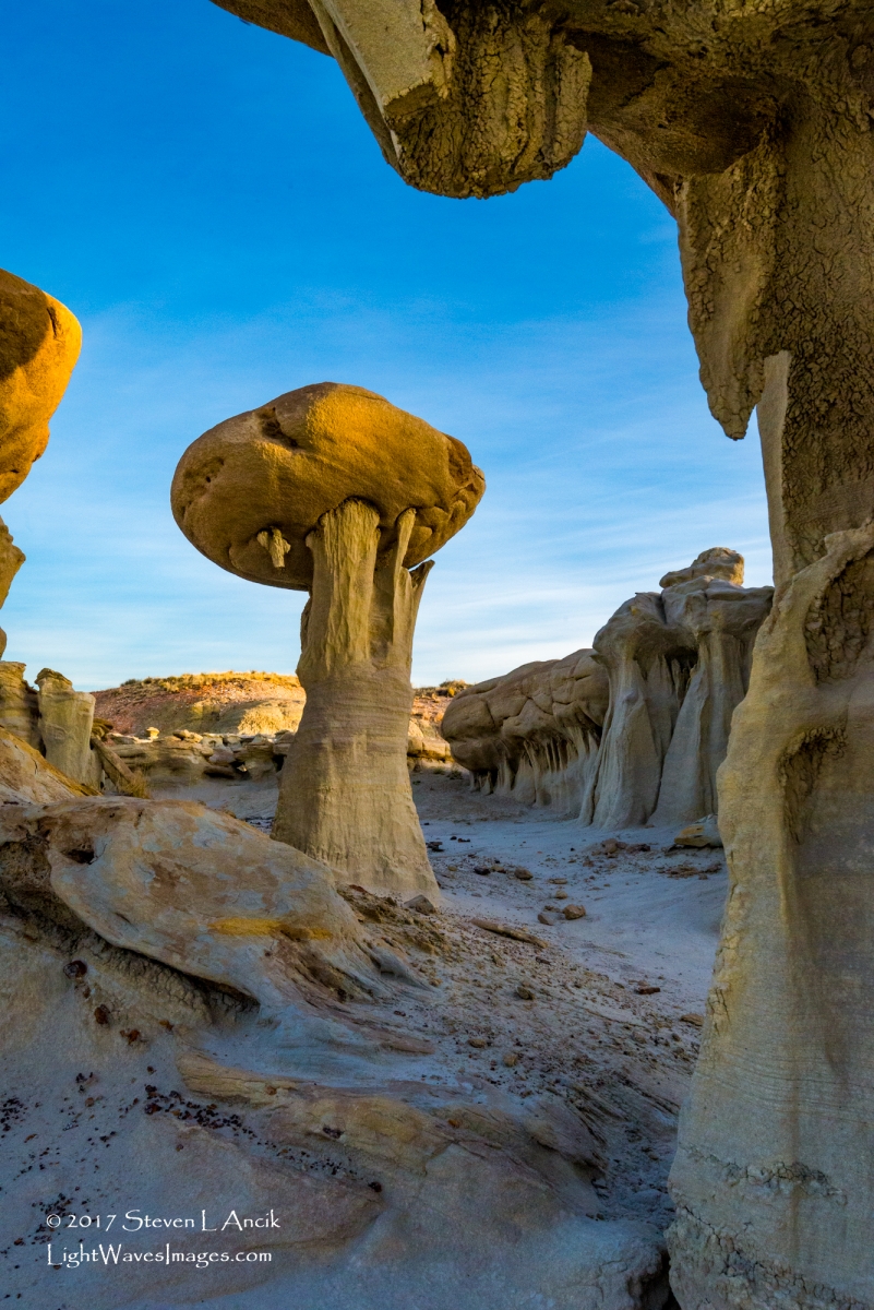


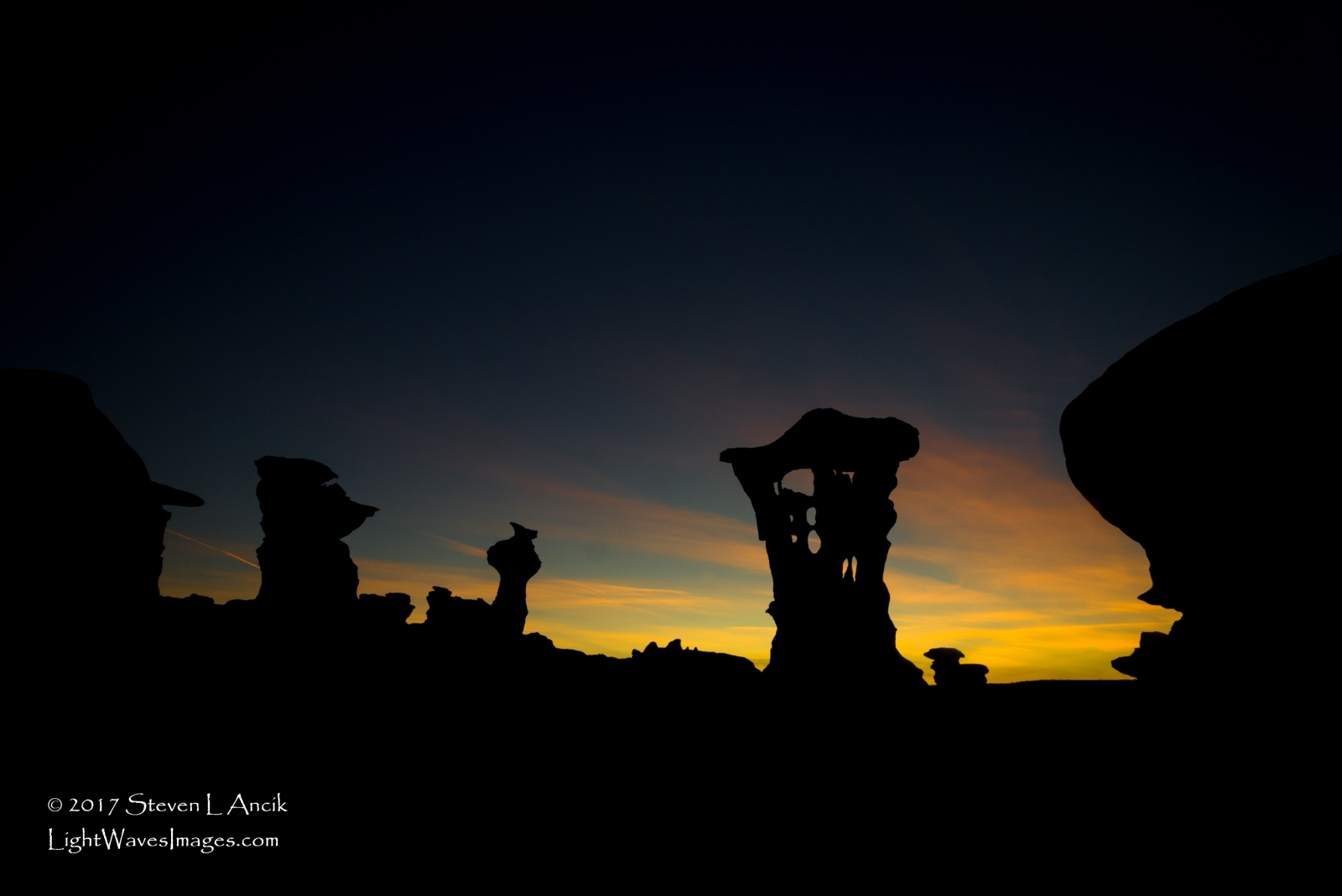
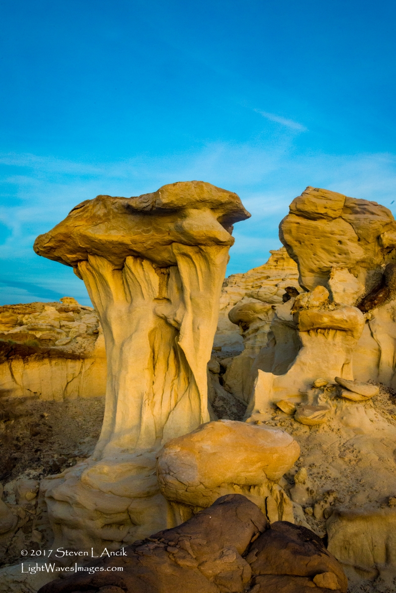
.thumb.jpg.98fd32503d3245c8fac64c0ee79819f6.jpg)


.jpg.b247ed4b913db5ff82fcb043892c9fca.thumb.jpg.3d872db3c824dd10508ef68affb4ee79.jpg)