A Bailey Range Traverse: Hiking in Olympic National Park
Entry posted by eliburakian in Trips ·
231 views
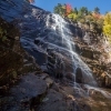
We were five days into a trek across Olympic National Park – at low elevation in mid-summer. Even though I was tired and about as cold as I think I've ever been, I was relishing the experience. I knew it was always the hard days that we remember most, and most of the days on this trip were hard. Really hard. And after this experience down at Cream Lake I knew I’d be able to tell a good story.
We also remember the beautiful days. Our ten-day journey – our own take on a traverse of the Bailey Range – along trails and backcountry from Lake Crescent in the north of Olympic National Park to the Quinault River Basin in the south fulfilled both the “hard” and “beautiful” criteria in spades.

When my son entered the world in December 2013, I knew 2014 was going to be a particularly difficult year to find time for adventure. I wanted a hike that was accessible, challenging both physically and mentally, and yet with an authentic “remoteness.” Ideally the route would travel through varying types of terrain, and it needed to be at low elevation as the timeframe was just too short to acclimatize to anything over 10,000 feet and still enjoy it.
A Bailey Range Traverse Begins
A traverse of the Bailey Range in Olympic National Park seemed to fit the bill perfectly. I had done day hikes in the old growth forests of the park and had hiked most of the 70 miles or so of wilderness coastline and I was in love. I knew I needed to delve much deeper into this magical place.
The Bailey Range flanks Mt. Olympus, the tallest and most glaciated peak in the park. A classic traverse of the range leaves from the Sol Duc Trailhead, along trails up past Heart Lake and onto the High Divide. We wanted to extend the trip a bit, so decided to follow the first sections of the traverse as noted in Olympic Mountains: A Climbing Guide, the premier climbing/hiking book about the park. We’d take the Boulder Creek Trailhead to Boulder Lake and head backcountry from there to Appleton Pass and from Appleton Pass to Cat Basin before getting on the main portion of the Bailey Traverse. If time permitted, we hoped to finish by hiking the Skyline Ridge Trail instead of following the North Fork of the Quinault River down from the Low Divide.
Unfortunately, the Boulder Creek Trailhead was closed due to a major dam removal project, so we started from Lake Crescent. After some crazy rental car logistics and a bus trip we started late in the afternoon of August 29th.

On this trip we took and used a bear can as well as technical mountaineering gear, which combined added an additional five pounds and some bulk. That, along with ten days of food, made for a heavy pack and we were happy to make the first day a very short one. We had crossed over Barnes Creek on a 150-foot log bridge made from one single tree, and we camped next to the creek, surrounded by huge conifers and large leafy plants.
Day 2 and Into the Olympics
Day two involved a long climb of over 4,000 vertical feet up to the Aurora Ridge Trail to the Happy Lake Trail and finally to Boulder Lake. On our way up, as we reached about 4,000 feet of elevation, a layer of fog suddenly appeared in trees, unmoving, ghostlike, and magical.
We hadn’t seen a soul the entire day and when we got to Boulder Lake, we camped on a peninsula surrounded on three sides by steep walls. Before hitting the sack, we heard another couple come in but never laid eyes on them.

A Bailey Range traverse campsite.
Day 3: Slow Going
Day three was probably the most physically exhausting of the trip – and the slowest. Counting our break time, it took us nine hours to make it just six miles! Why so long? Were there technical sections, crazy river crossings and lots of vertical? Nope. There were blueberry bushes. Oh the deadly blueberry bushes.
We climbed up and down, over rocks and ridges, past beautiful lakes and eventually to the Appleton Pass Trail just south of Appleton Pass. The entire off-trail route was covered in blueberry bushes, and as it was misting all day, it was slick. There was very little purchase for our feet, and it was all sloped downhill. The heavy packs didn’t help things. We were happy to set up camp when we reached Appleton Pass.
Day 4: The Bailey Range Traverse Proper
The next morning we were treated to an incredible sunrise on the surrounding peaks. Knowing that we didn’t want a repeat of yesterday, and that we didn’t want to be done before even starting the actual traverse, we chose to take a slightly longer but significantly easier route using trails. We followed the Appleton Pass Trail down to the Sol Duc River Trail where we climbed up to Heart Lake. Just above and beyond Heart Lake is the turnoff to the High Divide Trail, where the traverse of the Bailey Range really begins.

From my understanding, the Civilian Conservation Corps created this trail before World War II. It follows along a ridge before skirting the edge of Cat Basin and then contours around Cat Peak. This trail is an incredible sight to behold as it’s cut right into a steep mountainside with the Hoh River Basin dropping dramatically to the south. Originally, the High Divide Trail was supposed to cross much of the Bailey Range and meet up with the trail at Dodger Point; however the project was abandoned at the beginning of WWII. Basically, the trail just ends at a drop-off and we had to climb up a very steep eroding way-trail for a few hundred feet to reach the shoulder of Cat Peak.
According to many hikers, the next section was the crux. We had to cross the Catwalk, a technical arête which crosses between Cat Peak and Mt. Carrie. Many people camp at Boston Charlie’s, which is a camp located on the far (east) side of the Catwalk. But visibility was dropping, rain was coming in and the wind was blowing hard. We decided to save the Catwalk for the next morning and set up camp on the shoulder of Cat Peak just above the Catwalk. We knew water would be hard to come by so we had carried numerous liters up from Heart Lake. It turned out to be an interesting night. First, just as Jevan and I were discussing the fact that we probably wouldn’t see anybody else now that we were hitting the more remote portion of the trip, out popped two hikers who were coming from the Catwalk. We came to find out that it was a father and son team, and after spending a long time trying to cross the Catwalk in deteriorating conditions, they decided to turn around and ended up camping next to us.
A Fifth Day in the Bailey Range
The beginning of day five started out sunny and beautiful. From our ridge we were afforded our first incredible views of Mt. Olympus across the Hoh River Valley to our south. Low clouds filled the valley and the gigantic Blue Glacier radiated the early morning sun. Thinking we finally had a perfect day, we took our time getting ready. That was probably not the wisest decision, as the clouds and wind started rolling in by 9am and the day turned out to be the roughest and most emotionally and psychologically draining of the trip.

The Catwalk began with a tricky traverse along the side of a ridge. The narrow trail fell away below. Once onto the arête, we had to make our way across some short but technical sections. Doing all this with a large pack made the going much tougher. The section was short but exhilarating and in less than 45 minutes from camp we were at Boston Charlie’s, which did indeed have water.
Even though the Bailey Range traverse is technically a route, not a trail, enough people do it that there is an informal path for some of the way. We followed it as it contoured along the side of Mt. Carrie. The wind was picking up and by 11am we had 100-foot visibility, sideways rain with a constant 30mph wind and no shelter to speak of as the route was almost entirely above timberline. The trail became increasingly difficult as it crossed steep, wet, unconsolidated gullies. The temperature was probably in the upper 30’s but the wind-chill and rain made it feel much, much colder.
Most people head down to Cream Lake. With limited visibility we continued contouring until the path petered out at a gully that was too steep to cross. Instead, we half walked, half butt-slid down a steep rocky streambed to a meadow and eventually to Cream Lake. During an extremely brief window when the rain stopped, we set up our tent on a gravel bar next to the lake.

Typical for the Pacific Northwest, our traverse of the Bailey Range featured its share of moisture that turned to ice with overnight temperatures.
Day 6
Luckily for us we woke to bright blue skies with a rapidly warming day. Our wet gear was coated with ice, and we put everything we owned out on the “beach” to dry. By noon we were finally feeling like ourselves again. We left Cream Lake around 1pm, thankful for a beautiful day and glad the last section was over.
We followed an inlet stream up the valley and came within one hundred feet of a big bear that was slowly ambling by. He didn’t seem to care much about us and walked on past. Soon after, we were stymied by a steep wall with no real idea of where to go. After following the wrong stream for a while, we were able to get back on route and followed a ridge up to Ferry Basin where we set up camp above treeline next to a beautiful alpine lake. The lake was surrounded by incredible wildflowers, and as sunset approached, the clouds flowed up the valley toward us. Just when we thought we were going to be stuck in the middle of a cloud for the night, the fog was sucked back down the valley as it took on the bright pink hue of dusk. It was as if the air itself was glowing while the mountains took a final breath for the evening.
Day 7: The Route Continues
We woke the next morning in the cold rocky moonscape and continued on our route. As the day wore on Mt. Olympus seemed so close we could touch it and eventually we set up camp on the edge of the Queets Basin at what was without a doubt our most beautiful (and windiest) campsite of the trip. We climbed a small peak just to our east and took in a stunning sunset. We could see the ocean down the Queets River Basin and beautiful alpenglow shone off the snow-covered patches on nearby peaks. Our first day without having seen another person (Jevan had spotted a hiker on a nearby peak a day earlier) we climbed into our sleeping bags satisfied that this day exceeded our expectations for beauty and adventure.

High alpine terrain on our Bailey Range traverse.
Day 8
Day eight began sunny as we climbed down to Dodwell-Rixon Pass and said goodbye to the Bailey Range and headed down the Elwha Snow Finger. In a typical normal or high snow year, or in early season, hikers can make quick progress as they scamper down on top of the thick snowpack that fills the valley even in late summer. After a dry spring and hot summer, the Snow Finger had withered away. We traversed the snowfield for a few hundred feet and then alternated going around on the steep banks, rock-hopping and moving quickly past a number of huge snow bridges.
A choke point in the river led to a steep scramble out of the valley and down to a meadow. We then bushwhacked through dense alders, waded across the river and finally reached the Elwha River Trail. We made quick progress down to Chicago Camp and up to the Low Divide.
Hiking to the Finish Line
We decided to finish by hiking the Skyline Ridge Trail. This was a last-second decision and we didn’t know anything about the trail. Luckily (or so we thought) we ran into a guy who had just come along that trail, gave us a bunch of beta and told us there was no water up to the high point, but plenty after that.
Unfortunately for us, Washington was experiencing the hottest days of the summer. We stopped for lunch near a small tarn not far from Lake Beauty. By the end of lunch, it must have been over 100 degrees and after struggling for another hour up exposed (to the sun) rock, we decided to take a mid-afternoon siesta. Starting out again around 5 o’clock, we were able to enjoy the strange rocky moonscape below Kimta Peak. We arrived at Kimta Peak just as the sun was setting, and we were treated to a magnificently multi-hued sky as we watched the glowing orb set over the Pacific Ocean.

We had already hiked about fifteen miles and were happy to do the final five mostly downhill to the Three Prune Campsite. Strangely, there had been plenty of water on the way up and we had carried too much. Having drunk most of it, however, we were glad to know there were plenty of water sources on the way down. For the first half mile along the ridge we had stunning, unobscured views to the west.
Once the ambient light had fled and we were cruising through forest, we both came to the realization that our helpful hiker had led us astray. He had mixed up his directions and there was no water to speak of. Very thirsty and tired, we raced down the trail. By the time we arrived at camp, we were so tired that all we could do was drink up and pass out. The next day was a leisurely stroll through beautiful old growth forests, past the Three Lakes Campsite and out to the car with lighter packs and even lighter hearts.
Need to Know
Information
Bear cans are required, but you can rent them very cheaply from the Olympic National Park ranger station (and they've got the lightweight Bearikades to use!). The higher portions of the route involve snowfield and possible glacier travel. You'll also need to get a backcountry permit and give your itinerary to the rangers before heading out.
Getting There
There are numerous places to start, but if you're going from the north, you can base your operations out of Port Angeles. There are supermarkets and outdoor gear stores as well as a ranger station. If you leave from Lake Crescent as we did, you can catch a public bus to the trailhead. The closest major airport is in Seattle and you'll probably want to take the ferry over to the Olympic Peninsula. There is no public transportation to the southern trailhead at either the North Fork Quinault River Trail or the Irely Lakes Trail just down the road so you'll need to drop a car or arrange for a pickup.
Best Time to Go
It depends on the year, but most hiking in the high alpine sections of the park have a short window from July through early September if you don't want to be dealing with much snow.
Maps and Books
I used Caltopo.com to print my own maps on waterproof paper. I also carried the National Geographic Trails Illustrated map of Olympic National Park and I used a phone app on my smartphone, which allows you to download detailed topo maps prior to your trip and utilize the GPS functionality of your phone without cell service. For books see Olympic Mountains: A Climbing Guide. For a more general guidebook on the park, see Hiking Olympic National Park.
Editor's Note: This article Eli Burakian originally appeared in an online magazine form in TrailGroove Magazine and has been republished here.
0 Comments
Recommended Comments
There are no comments to display.
Create an account or sign in to comment
You need to be a member in order to leave a comment
Create an account
Sign up for a new account in our community. It's easy!
Register a new accountSign in
Already have an account? Sign in here.
Sign In Now